

Sightseeing spots by ship or boat

Ferry to Miyajima
Japan is an island country and is surrounded by the sea.
The land is mountainous and there are many rivers and gorges.
And lakes and ponds are dotted.
In wide see and lake, sightseeing boats are operated.
Because the rivers in Japan are narrow and flow often rapidly, small-sized boats are used and some boats are operated with pole by the boatmen.
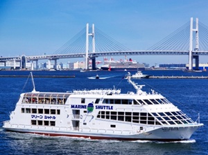
In Tokyo and Osaka, the cruises by small sightseeing boat called Water-bus are operated on the rivers and canals in the central area.
And, houseboat called Yakatabune is also popular in these cities.
The passengers can enjoy Japanese foods in the Japanese room on the boat while watching the cityscape on the water of the river.
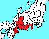
River cruises in two big cities in Japan
River cruises in central Tokyo River cruises in central Osaka
Sightseeing spots by ship or boat across Japan


River cruises in central Tokyo

Sumida River flows from north to south through the northeast part of central Tokyo and into Tokyo Bay.
The width of the river is 150 to 200 meters and the water flows slowly.
Because it flows through the urban area, the water is not clear.
Sumida River flows near the popular old towns such as Asakusa, Ryogoku and Tsukiji.
And there is Odaiba area near the river mouth.
So water-buses are operated between Asakusa and Hinode Pier facing Tokyo Bay.
They stop by at Hamarikyu Gardens.
Nihonbashi is the the center of economy in Japan and it had been a center of ship transportation in the old days.
Some canals connect Nihonbashi and Sumida River.
So many river cruises are operated from Nihonbashi.
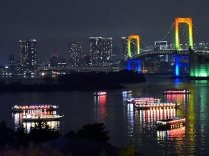
Yakatabune around Odaiba area in the evening
Many Yakatabune are operated and the boarding place are dotted along Sumida River.
The followings are main Yakatabune companies.
River cruises in central Osaka

Osaka is the central city of western Japan.
Yodo River flows in the north part of the city, and the tributary flows through the center of the city.
There is a long sandbank Nakanoshima in the central part of the city.
It had been the economic center of Japan because the products from throughout the country were collected here in the old days.
Even now, the area is the administrative and economic center of Osaka.
And many canals had been set up for water-carriage in the city in the old days.
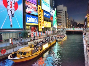
Sightseeing boats in Dotonbori
Now, in remaining rivers and canals, water-buses and yakatabune are operated for tourists.
The main areas are Nakanoshima, Osaka Castle, Dotonbori and Osaka Port.
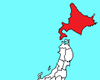
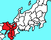
Sightseeing spots by ship or boat in eastern Japan
Hokkaido Region
Otaru Canal (小樽運河)
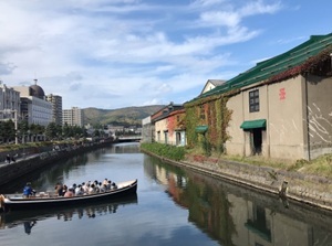
Otaru Canal is at the edge of the central part of Otaru city.
It separates the city from the harbor area.
It was built for discharging of cargo from ship in 1923.
The retro atmosphere is popular.
The cruise boat sailing on the canal and harbor is operated.
Shakotan Peninsula (積丹半島)
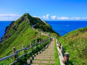
Shakotan Peninsula is a peninsula extending from the west of Otaru city to the northwest.
Whole area is mountainous and small villages are dotted along the coastline.
And there are various scenic spots of the sea are along the coastline.
The color of the sea is beautiful.
From Bikuni port in the central village, a pleasure ship leaves for seeing into the sea.
Lake Shikotsu (支笏湖)
Lake Shikotsu is a caldera lake by eruption of volcano.
It is located about 30 km south of Sapporo city, and is located about 20 km west of Shin-Chitose Airport.
There are three active volcanos near this lake.
This lake doesn't freeze in winter.
From the eastern lakeside, the pleasure boats is operated.
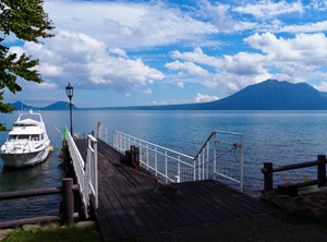
Lake Toya (洞爺湖)
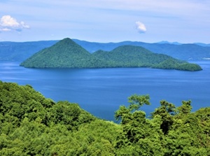
Lake Toya is a scenic caldera lake by eruption of volcano.
It is located about 35 km west-southwest of Lake Shikotsu.
The shape of the lake is almost circular and there is an island in the center.
There is the onsen town on the lakeside.
Around the lake, there are an active volcano Mount Usu (有珠山, 737 m) and a new volcano Showa-shinzan (昭和新山, 398 m) which appeared suddenly from 1943 to 1945.
Sightseeing ship leaves from the resort area on the soutjern lakeside.
Drift ice (Ryuhyo) cruise
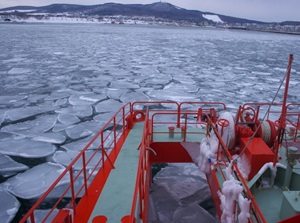
Drift ice comes ashore around the northeastern coast of Hokkaido facing Okhotsk Sea from late January to early March.
It is called "Ryuhyo" (流氷) in Japanese.
The sea water is frozen in the northern part of the Okhotsk Sea, and is carried toward the south by sea currents.
Abashiri city and Monbetsu are popular sightseeing cities for the drift ice.
The cruising ships in ryuhyo are operated in the season from the ports.
Shiretoko Peninsula (知床半島)
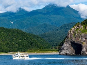
Shiretoko Peninsula is a long peninsula extending about 70 km toward northeast like a horn.
The northern half of the peninsula is uninhabited and is covered by primeval forest.
So, the area was registered as a World Natural Heritage Site.
There are Utoro and Rausu villages at the entrance place to the area.
These are the base of sightseeing for Shiretoko Peninsula.
In winter, drift ice is seen on the Okhotsk Sea side.
Lake Akan (阿寒湖)
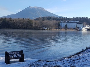
Lake Akan is a caldera lake and is located about 60 km north of Kushiro city in the eastern part of Hokkaido.
It is at the foot of two volcanoes.
There are the onsen town and the village of Ainu people.
The lake is famous for "Marimo" which is a spherical moss.
There is Marimo Exhibition and Observation center on a small island in the lake.
The visitors can visit the island by the sightseeing ship.
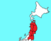
Tohoku Region
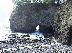
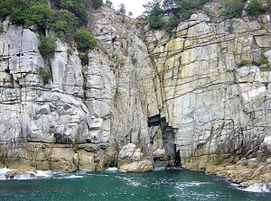
Hotokegaura (仏ヶ浦, Aomori Pref.)
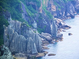
Hotokegaura is a part of western coast of Shimokita Peninsula shaped like an ax.
It faces Tsugaru Strait between Hokkaido and Honshu islands.
There are white uniquely shaped rocks and cliffs along the coast.
"Hotoke" means "Buddha".
The height of some rocks and cliffs are more than 100 meters, and they looks like great statue of Buddha.
The pleasure boats leave from Sai town located 15 km north of Hotokegaura and it is operated from late April to the end of October.
Lake Towada (十和田湖, Aomori Pref.)
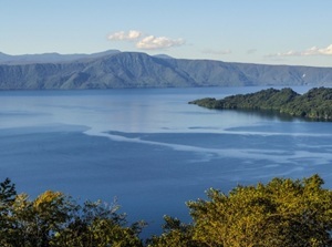
Lake Towada is a caldera lake, and it is located to the south of Mount Hakkoda.
Oirase stream flows into the lake, and it is also a popular sightseeing spot around Lake Towada.
Yasumiya village on the southern lakeside is the base of the sightseeing.
A sightseeing ship is operated from Yasumiya.
Jodogahama (浄土ヶ浜, Iwate Pref.)
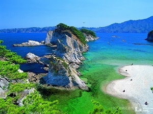
Jodogahama is a scenic beach facing the Pacific Ocean.
It is one of the sightseeing spots of long and steep Sanriku Coast.
The beach is located about 3 km northeast of Miyako city which is the centrat city in the area.
A sightseeing ship is operated from Miyako port.
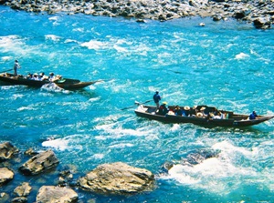
Geibikei (猊鼻渓, Iwate Pref.)
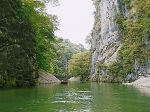
Geibikei is a gorge along Satetsu River.
It is located about 14 km northeast of Ichinoseki city in Iwate Prefecture.
There are limestone cliffs over 50 meters high along the river.
And, strange rocks, waterfalls and limestone caves are dotted.
A small pleasure boat rowed by boatmen is operated.
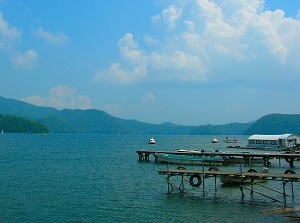
Lake Tazawa (田沢湖, Akita Pref.)
Lake Tazawa is a small round lake about 6 km in diameter.
It is located about 70 km east of Akita city.
It is the deepest lake in Japan and the depth is 423 meters.
The deep blue color of the water is attractive.
From late April to early November, a sightseeing ship is operated.
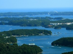
Matsushima (松島, Miyagi Pref.)
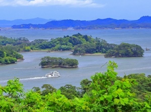
Matsushima is a scenic bay with many small islands.
It is located 20 km northeast of central Sendai city.
Since ancient times, Matsushima has been known as a very scenic place.
And, there are the famous buddhist temples, Zuiganji and Entsuji, near the coast.
Some sightseeing ships cruising the bay are operated by two shipping companies.
Mogami River (最上川, Yamagata Pref.)
Mogami River is the main river in Yamagata Prefecture.
It flows in the center of the prefecture and main cities are along the river.
The width of the river is totally wide, so it had been the important traffic route in the area in old times.
The boat tours are operated in the middle reach.
Lake Inawashiro (猪苗代湖, Fukushima Pref.)
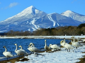
Lake Inawashiro is located about 15 km east of Aizu-Wakamatsu city.
It is at the southern foot of Mt. Bandai, so it is a scenic place to see the mountain.
The water of lake had been very acid under the influence of the volcanos, but it is closer to neutral water now.
In winter, many swans come flying on the north and east shore of the lake.
From early April to the middle of November, pleasure boats are operated.
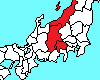
Kanto Region
Lake Chuzenji (中禅寺湖, Tochigi Pref.)
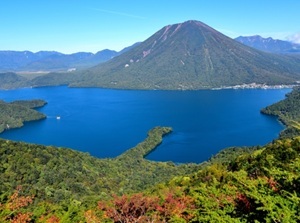
Lake Chuzenji is a dammed lake by the eruption of Mt.Nantai.
It is located to the west of sacred city Nikko.
There is famous Kegon Falls at the place that a river flows out from the lake.
The river flows down to the main area of Nikko city.
It is another sightseeing spot of Nikko.
The pleasure boat is operated from the middle of April to the end of November.
Junikyo (十二橋, Chiba & Ibaraki Prefs.)
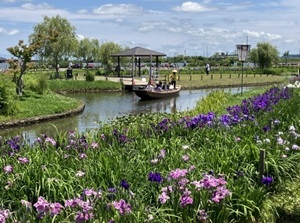
Junikyo are the twelve small bridges over the narrow canal.
The area is in Itako city in Ibaraku Prefecture and Katori city in Chiba Prefecture.
The area is in the lower section of large Tone River, so many canals had been the ways in the daily life.
Iris gardens are well-known.
The boat cruises visiting Junikyo is popular.
Nagatoro (長瀞, Saitama Pref.)
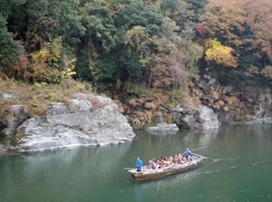
Nagatoro is a gorge on the upper part of Arakawa River flowing to Tokyo.
It is located in the western part of Saitama Prefecture.
The gorge is about 6 km long, and there are various rocks and cliffs which are geologically interesting.
So, it was designated as a national nature treasure and a beauty spot.
The tourists can see various spots from small boat.
Yokohama (横浜, Kanagawa Pref.)
Yokohama is a big city to the south of Tokyo.
The city has developed as the harbor city of Tokyo since the 19th century.
Yokohama port is a major sightseeing spot.
Some cruising ships are operated around the port.
Yokosuka (横須賀, Kanagawa Pref.)
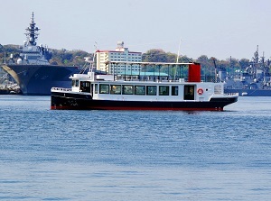
Yokosuka naval port cruising
Photo by by TRYANGLE
Yokosuka is a city to the south of Yokohama.
It has developed as the city of naval harbor because it is located at the entrance of Tokyo Bay.
Now, the port area has been used as the bases of United States Navy and Japan Maritime Self-Defense Forces.
There was a tense atmosphere, but Yokosuka naval port cruising is operated for tourists.
Guide to Yokosuka naval port cruising
Lake Ashi (Ashinoko, 芦ノ湖, Kanagawa Pref.)
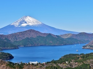
Lake Ashi is a caldera lake in Hakone.
It is about 6 km long from north to south, and the width is about 0.6 to 1.5 km.
There is the caldera cone on the east side of the lake, and the caldera wall of outer rim is on the west side.
It is a scenic spot of Hakone and Mt.Fuji is also seen.
Two companies operate the pleasure ships.
Koshinetsu Region
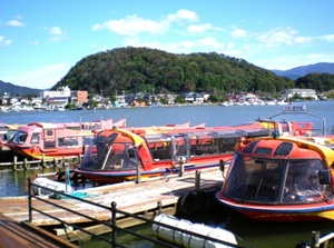
Lake Kawaguchi, Lake Motosu, Lake Yamanaka (河口湖, 本栖湖, 山中湖, Yamanashi Pref.)
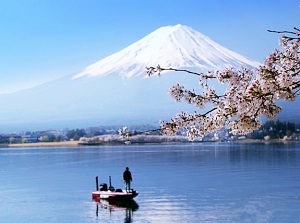
Lake Kawaguchi in spring
Lake Kawaguchi, Lake Motosu, Lake Yamanaka are the lakes at the northern foot of Mt.Fuji.
There are main five lakes around Mount Fuji, and these are three of them.
The beautiful shape of Mount Fuji is seen from all lakes.
The pleasure ships are operated in above three lakes.
Lake Nojiri (野尻湖, Nagano Pref.)
Lake Nojiri is a small lake located about 20 km north of Nagano city.
It is at the level of 654 meters and was developed as a summer resort for foreigners in the 1920s.
Since that, here had been the resort area where many foreigners had visited.
A pleasure ship is operated.
Lake Suwa (諏訪湖, Nagano Pref.)
Lake Suwa is located in the center of Nagano Prefecture.
It is at the level of 759 meters and it is frozen sometimes in winter.
There are four sites of Suwa-taisha shrine around the lake.
The festivals related to the shrine are held around the lake.
And, the firework festival in summer are famous as the sightseeing objects.
A pleasure ship is operated.
Tenryukyo (天竜峡, Nagano Pref.)
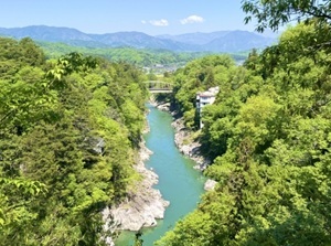
Tenryukyo is a gorge formed by Tenryu River.
The river frows from Lake Suwa in the center of Nagano Prefecture to the south.
It is a gorge in the middle reach of the river, and narrow and steep valley has been formed.
The tours by boat are operated.
Sasagawa-nagare (笹川流れ, Niigata Pref.)
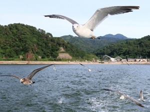
Flying sea gulls near pleasure boat
Sasagawa-nagare is a coast facing the Sea of Japan, and is located in the northern part of Niigata Prefecture.
Many uniquely shaped rocks are seen, and the clear water of the sea and the view of sunset are beautiful.
Pleasure boats are operated, and feeding the flying sea gulls on the boat is popular.
Hokuriku Region
Shogawa Gorge (庄川峡, Toyama Pref.)
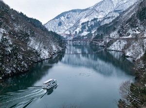
Shogawa Gorge is a gorge formed by Shogawa river flowing in the western area of Toyama Prefecture.
The winding dam lake is the main part.
And the surface of the river is very calm.
The mountains on the both sides of the river are covered with deep forest.
The cruising ship is operated.
Ganmon cave (巌門, Ishikawa Pref.)
Ganmon cave is a sea cave on the western coast of Noto Peninsula.
Cliffs, gigantic stones, odd rocks, and caves are lined about 30 km along the western coast around Ganmon, and the cruising ship is operated.
The area was damaged by the great earthquake and tsunami on January 1, 2024.
But the cruising has been restarted.
Tojinbo (東尋坊, Fukui Pref.)
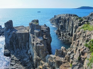
Tojinbo is the very steep rocky coast facing the Sea of Japan.
It is located about 20 km north of Fukui city.
The cliff with a lot of columnar joints for 1 km is one of the rare places in the world.
So, it is designeted as a national natural treasure.
We can view from the pleasure boat.
Mikata-goko lakes (三方五湖, Fukui Pref.)
Mikata-goko is a group of five small lakes facing Wakasa Bay.
It is located about 20 km west of Tsuruga city.
All lakes are connected with a narrow channel or a canal.
The shape of the lake is complicated and the hills between the lakes make the appearnce of beautiful scenery.
A scenic road is set up and a pleasure boat is operated.
Sotomo cliffs (蘇洞門, Fukui Pref.)
Sotomo cliffs are the steep rocky cliffs facing the Sea of Japan.
It is near old Obama city.
The cliffs are formed by granite columnar joint.
These has been eroded by wild waves, so uniquely shaped rocks, caves and waterfalls are seen.
The pleasure boat start from a commercial facility Wakasa Fisherman's Wharf in the port area.
Tokai Region
Dogashima (堂ヶ島, Shizuoka Pref.)
Pleasure boat near Tensodo
Dogashima is a coast with some small rocky islands.
It is located in the west coast of Izu Peninsula.
Various rocky cliffs and coasts are seen.
Especially, a sea cave named Tensodo is popular, and the ceiling with a big hole is very unique.
We can visit by pleasure boat.
Guide to Dogashima on West coast of Izu
Lake Hamana (浜名湖, Shizuoka Pref.)
Kanzanji onsen town
Photo by Shizuoka Prefectural Tourism Association
Lake Hamana is a scenic lake connected to the Pacific Ocean.
It is located near the southwestern end of Shizuoka Prefecture and is about 10 to 15 km west of the center of Hamamatsu city.
Shinkansen runs on the southern edge of the lake, so the passengers can the view of the lake from the train window.
There is Kanzanji onsen town on the northern lakeside and pleasure ship is operated.
Ukai (鵜飼, Gifu, Aichi Prefs.)
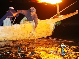
Nagara River Ukai
Photo by Gifu City
Ukai is an old fishing method to catch the river fishes using cormorants.
It has been done since the 8th century.
Now, Ukai fishing for the Emperor is done several times a year, and the fishes are dedicated to the Emperor.
Ukai on Nagara River in Gifu city and Kiso River in Inuyama city in Aichi Prefecture are famous.
The traditional fishing performance is seen as a show on the boat in the evening.
Guide to Ukai in Gifu city Guide to Ukai in Inuyama city
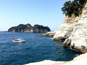
Toba (鳥羽, Mie Pref.)
Toba is the sightseeing city facing the sea with some islands.
It is at the northeast part of Shima Peninsula in Mie Prefecture, and is located about 15 km east of Ise city with sacred Ise Shrine.
Mikimoto Pearl Island is the place that cultured pearls had been produced for the first time in the world.
And "Ama", the traditional woman divers who fish for the pearl oysters, are well-known.
A pleasure ship which travels around the islands is operated.
Ago Bay (英虞湾, Mie Pref.)
Ago Bay is on the south side of Shima Peninsula.
It is located about 25 km south of Toba city.
Many small islands are in narrow Ago Bay.
There are a few observatories on the hills around the bay, and the views from there are very attractive.
A pleasure ship around Ago Bay is operated.
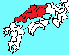
Kansai Region
Hozu gorge (保津峡, Kyoto)
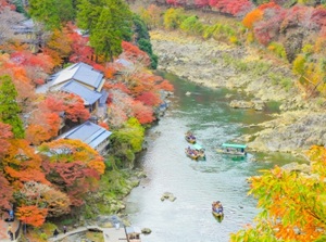
Hozu gorge is a gorge formed by Hozu River.
Hozu River is upstream of Katsura River in Arashiyama in Kyoto.
The length of the gorge is about 12 km.
Cruising by small boat is operated between Arashiyama and Kameoka city.
And, a sightseeing train runs along the gorge.
Amanohashidate (天橋立, Kyoto Pref.)
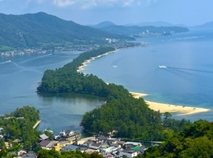
Amanohashidate is a scenic sandbar.
It is in Kyoto Prefecture, but it is located near the Sea of Japan far from central Kyoto city.
The shape of the sandbar looks like a dragon going up to heaven, so it has been a popular place since ancient times.
There are the observatories to see it on the hills.
And, the pleasure boat sailing around the sandbar is operated.
Ine (伊根, Kyoto Pref.)
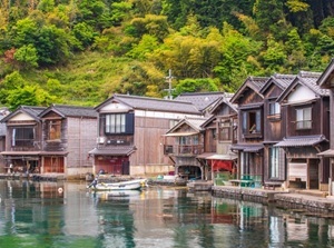
Ine is a small fishing village facing a cove and is located about 90 km north-northwest of Kyoto city.
There are unique houses of fisherman called "Funaya" along the seaside.
The garage of ship is located on the first floor, and the dwelling is on the second.
The scenery of the houses is popular.
The tour boat and sea taxies which travel around the cove are operated.
Doro Gorge (瀞峡, Wakayama Pref.)
The bording point to Doro Gorge
Doro Gorge is a gorge formed by Kitayama River.
It is located about 30 km north of Shingu city in Wakayama Prefecture.
The area is deep in the mountain and only a few small villages are dotted along the river.
The river contains a great volume of water, and many high cliffs, huge rocks, strange rocks and caves are seen.
These are seen from a sightseeing boat.
Nanki-Katsuura (南紀勝浦, Wakayama Pref.)
Nanki-Katsuura is the onsen resort facing the Pacific Ocean.
It is in Nachi-Katsuura town located in the southeastern part of Wakayama Prefecture.
Some hotels and ryokans are dotted in the town and a few hotels are on the small peninshula surrounding the port.
It is located near the sacred "Three Grand Shrines of Kumano" and it is on the ancient pilgrimage routes "Kumano Kodo".
Kumano Nachi Taisha shrine and Nachi Falls are close to the town.
There are the scenic islands called "Ki-no-Matsushima" near the port.
A pleasure boat to see them is operated.
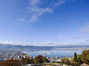
Lake Biwa (琵琶湖, Shiga Pref.)
Otsu city and Mt. Hiei by Lake Biwa
Lake Biwa is the largest lake in Japan.
The lenght from north to south is about 80 km, and the length at the widest part from east to west is about 25 km.
It occupies the wide area of Shiga Prefecture.
There is Otsu city at the southern end of the lake and Kyoto city is located just west of Otsu.
At Otsu port, the pleasure ships are opearted.
Kobe (神戸, Hyogo Pref.)
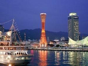
Kobe Port
Kobe is a port city along with Yokohama.
It is located about 30 km west of Osaka and is in Hyogo Prefecture.
The port was open for trading with foreign countries in 1868 after Yokohama.
Then, the city developed.
Many old Western-style houses in those days remain in a few district.
Some cruising ships are operated around Kobe Port.
Chugoku Region
Kurashiki (倉敷, Okayama Pref.)
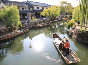
Kurashiki was a distribution center of various products of Okayama area in the 17th century.
It is located about 15 km west of Okayama city.
Around Kurashiki River like a canal, old buildings and warehouses are preserved.
The district is designated as a national conservation area of traditional buildings.
The river cruise by small boat is operated.
Hiroshima (広島, Hiroshima Pref.)
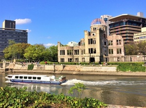
Hiroshima is a big city in Chugoku Region.
The city was destroyed by the first atomic bombing in human history in 1945.
Genbaku Dome is a living witness.
It has been designated as a World Heritage site.
Some rivers flow in the center of the city.
Genbaku Dome is on a riverside.
The river cruise to see it is operated on the river.
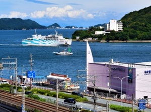
Miyajima Island (宮島, Hiroshima Pref.)
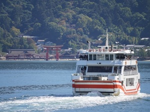
Miyajima Island is the island where Itsukushima Shrine is enshrined.
It is located about 25 km southwest of Hiroshima city.
Itsukushima Shrine is designated as a national treasure and a World Heritage Site.
The whole island is the sacred site of the shrine
To visit Miyajima, ferry boats are operated frequently.
Sandankyo (三段峡, Hiroshima Pref.)
Kurobuchi in Sandankyo
Photo : Hiroshima Prefectural Tourism Federation
Sandankyo is a gorge in the deep mountain in Hiroshima Prefecture.
It is around the upper Ota river and the river flows down to Hiroshima city.
It is located about 50 km northwest of Hiroshima city.
The gorge is about 16 km long and the walking trail 12 km long is set up.
Some water falls and various streams are seen.
There are two spots with a small ferry boat.
Matsue Castle (松江城, Shimane Pref.)
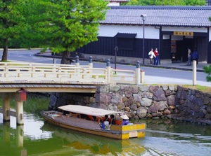
Matsue city is the main city in Shimane Prefecture and was the castle town of Matsue Castle.
Matsue Castle is one of the 12 castles in Japan that original castle tower remains.
There are some moats around the castle.
Small pleasure boat cruising the moats is operated.
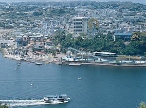
Lake Shinji (宍道湖, Shimane Pref.)
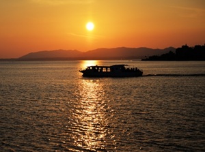
Sunset cruising on Lake Shinji
Lake Shinji is a brackish lake, and stretches to the west of central Matsue city.
Shijimi clam in Lake Shinji is well-known, and various fishes are produced.
The view of sunset is popular.
The pleasure ship is opearated.
Especially, the sunset cruising is popular.
Oumijima island (青海島, Yamaguchi Pref.)
Oumijima island is an island in the Sea of Japan, and is near Nagato city in Yamaguchi Prefecture.
There are sheer cliffs and rocks along the northern coast, and the landscape is called "Alps in the sea".
The pleasure ship visiting the coast is operated.
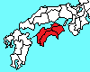
Shikoku Region
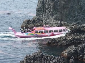
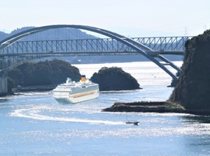
Naruto Whirlpools (鳴門の渦潮, Tokushima Pref.)
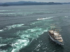
Naruto Whirlpools are the most popular and large-scale whirlpools in Japan.
The sea is a narrow strait between Naruto city and Awajishima island.
The whirlpools occur by moving of the massive amount of water between Seto Inland Sea and the Pacific Ocean by the rise and fall of the tides.
Pleasure boats approaching to the whirlpools are operated.
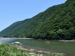
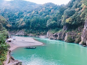
Oboke, Koboke (大歩危, 小歩危, Tokushima Pref.)
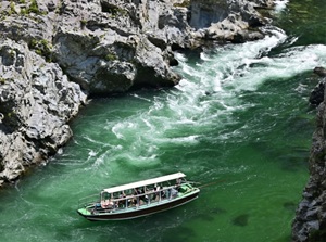
Pleasure boat around Oboke
Oboke and Koboke are the deep gorges formed by Yoshino River in Tokushima Prefecture.
Oboke has very rough rocks and river flows with a volume of water.
Koboke is about 6 km downstream of Oboke, and it is narrower, more winding, and faster river flows than Oboke.
Around Ôboke, small pleasure boat is operated.
And, around Koboke, we can enjoy rafting.
Shimanto River (四万十川, Kochi Pref.)
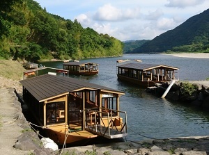
Shimanto River flows in the southwest part of Kochi Prefecture.
It is remote from major cities and does not have any dams.
Therefore, it is often referred to as the last clear stream of Japan.
There are unique "sinking bridges" to be carried away by the flood on purpose. Some sightseeing boats are operated.
Some sightseeing boats are operated.
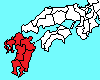
Kyushu Region
Yanagawa (柳川, Fukuoka Pref.)
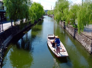
Yanagawa is a castle city near Ariake Sea.
The castle was built around the 1500s, but it was demolished in 1872 after the end of samurai period.
Many canals connecting to the rivers were constructed to defense of the castle.
The scenery is attractive, so Yanagawa is often called the city of water.
The boat tours are operated.
Yobuko (呼子, Saga Pref.)
Nanatsugama near Yobuko
Yobuko is a district facing Genkai Sea in Karatsu city in Saga Prefecture.
The squids unloaded at the fishing port are fresh and popular.
The morning market is popular and the fresh fishes and squids are sold.
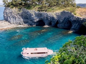
Nanatsugama is a cliff of columnar joint with seven sea caves.
The unique is located near a cape about 5 km east of the center of Yobuko town.
The pleasure boat is operated from Yobuko port.
Gunkanjima (軍艦島, Nagasaki Pref.)
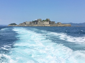
The view of Gunkanjima from the tour boat
Gunkanjima is a small island near Nagasaki city.
It had been a coal mine until 1974, and it looks like a warship because many buildings and facilities are on the island.
The island is a ruin but the island is designated as the World Cultural Heritage.
A few guided tours are operated from Nagasaki Port.
Kujukushima (九十九島, Nagasaki Pref.)
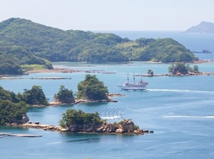
Kujukushima is a group of many small islands along the intended coast to the northwest of Sasebo city in Nagasaki Prefecture.
"Kujuku" means "99" in Japanese but it means a lot of islands.
In fact, there are over 200 islands.
The scenery is attractive and the view of sunset is beautiful.
The pleasure ships are operated from Kujukushima Pearl Sea Resort which is a complex facility.
Amakusa (天草, Kumamoto Pref.)
Amakusa is the islands on the west side of Kumamoto Prefecture.
There are many islands near the mainland.
Because Christianity was banned in Japan in 1587, Japanese Christians had hidden in Amaskusa until the lifting of the ban of Christianity in 1873.
So there are also a few Christian churches in Amakusa.
The pleasure ship cruising around the island is operated.
Kuma River (球磨川, Kumamoto Pref.)
Kuma River flows in the south part of Kumamoto Prefecture.
The section from Hitoyoshi to Yatsushiro cities is a narrow valley about 50 km long.
It has one of the swiftest currents in Japan.
The tours floating down the river are conducted near Hitoyoshi city.
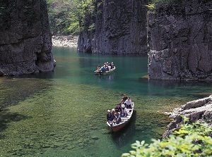
Takachiho Gorge (高千穂峡, Miyazaki Pref.)
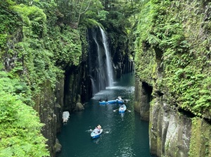
Takachiho Gorge is a gorge formed by Gokase River.
Because the rock is tuff, it is not so hard.
So, most of the cliffs in this gorge are very steep.
The gorge with Manai Falls is popular.
You can use the rental boat to enjoy the gorge.
Okinawa (沖縄)
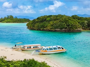
Kabira Bay in Ishigaki Island
Okinawa is the prefecture located on the southwestern edge of Japan.
Subtropical islands are dotted on a line for 650 km.
From the 15th to 19th centuries, the islands were Ryukyu Kingdom, so unique cultures remain.
Okinawa Island, Miyako Island and Ishigaki Island are the main islands.
There are many beach resorts in these islands.