
Railways for sightseeing


Railways for sightseeing in eastern Japan
Hokkaido Region
Sapporo city (札幌)
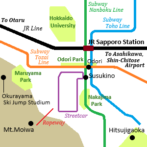
Railway map of Sapporo city
Sapporo is the large city in Hokkaido and is a popular sightseeing city.
It has has a population of about 1.9 million.
There is Sapporo terminal station of JR and many limited express trains to various destinations in Hokkaido depart from here.
Three lines of subway are operated by Sapporo City Transportation Bureau.
They run through JR Sapporo station, Odori Park and Susukino which are the popular place in Sapporo.
And there is a loop line of streetcar from Susukino.
Hakodate city (函館)
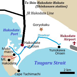
Railway map of Hakodate city
Hakodate is located at the southern tip of Hokkaido.
The city was opened as a trading port in the 19th century and there are some historical spots.
There is JR Hakodate terminal station near Hakodate Port.
Until 1988, the train ferry had connected Aomori in Honshu and here.
There are fertile fishing grounds around Hakodate, so Hakodate Morning Market near Hakodate station is a popular sightseeing spot that you can eat fresh fishes.
In the city, streetcar is operated by Hakodate City Tram Department.
The tourists can visit various sightseeing spots by it.
Tohoku Region
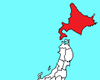
JR Gono Line
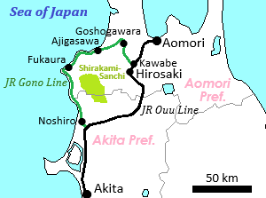
Map of Gono Line
Train of JR Gono Line
JR Gono Line is a local line in Aomori Prefecture.
It is a branch line of JR Ouu Line, and it runs along the Sea of Japan.
The line connects between Kawabe near Hirosaki city and Noshiro city.
The length is 147 km.
The 85-kilometer section between Ajigasawa and Noshiro is continuously near the coast.
The view from the train window is popular.
The train is operated once every two hours.
A few trains are the express to view the scenery.
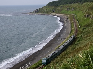
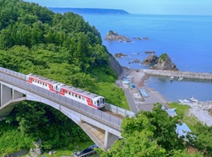
Sanriku Railway
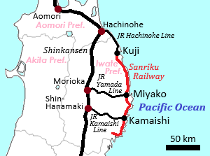
Map of Sanriku Railway
Train of Sanriku Railway
The east coast from southern Aomori Prefecture, through Iwate Prefecture and northern Miyagi Prefecture is called Sanriku Coast.
It faces Pacific Ocean and the length is about 250 km.
The coast line is the ria coast and has continuous steep cliffs.
When the Great East Japan Earthquake occurred in 2011, the massive tsunami hit the whole area of the coast.
But, there are many scenic spots around the coast.
Sanriku Railway runs along the coast.
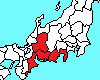
Sendai city (仙台)
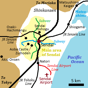
Railway map of Sendai city
Sendai is the largest city in Tohoku region.
It has has a population of about 1.1 million.
There is Sendai station of JR in the center of the city, and Tohoku Shinkansen stops here.
JR lines to Yamagata, Matsushima and Sendai Airport branch from here.
The plain is narrow, so the main area of the city is compact.
Two subway lines managed by Sendai City Transportation Bureau run in the area.
Aizu Railway & Yagan Railway
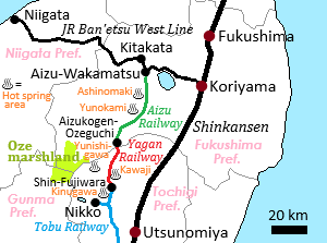
Map of Aizu Railway & Yagan Railway
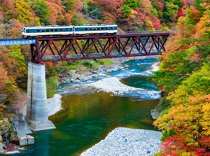
Train of Aizu Railway
Aizu-Wakamatsu is an old castle town in the western part of Fukushima city.
There are some historical spots and traditional crafts in the city.
JR Ban'etsu West Line from Koriyama is the main route to the city.
Another route is the line connecting between Aizu-Wakamatsu and Nikko.
It runs through the mountain areas and along the gorges.
Along the line, there are some hot spring resorts and scenic areas.
And, there is the entrance station to Oze marshland which is the Japan's largest mountain wetland and is a national park.
The length of the line is about 104 km, and three railway companies connect the line.
These are Aizu Railway, Yagan Railway, and Kinugawa Line of Tobu Railway.
Kinugawa Line of Tobu Railway is a branch line near Nikko, so the tourist can come to this line by limited express from Asakusa in Tokyo.
Kanto Region
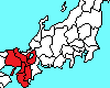
Yokohama city (横浜)
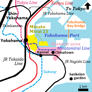
Railway map of Yokohama city
Yokohama is the second largest city after Tokyo.
It has has a population of about 3.7 million.
It is located just south of central Tokyo, and it is a part of Tokyo metropolitan area.
Most parts of the city are the commuter towns for Tokyo.
But, the city has the history that the city had been developed as an international trade port of Tokyo after the opening of Japan to the world in 1859.
Yokohama Port is the historic area and is the main sightseeing spot.
Kannai area is the historic town, and Chinatown and the foreign settlement around there.
Minatomirai area is the new waterfront area.
Yokohama station is the main station of the city and JR and some railways are connected.
It is located near Yokohama Port.
JR Negishi Line runs along these areas, and Sakuragicho, Kannai and Ishikawacho stations are set up.
And, Minatomirai Line runs underground the areas and it is connected to the Tokyu Toyoko Line.
Shin-Yokohama station of Shinkansen is located about 5 km to the northof Yokohama station.
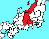
Enoden
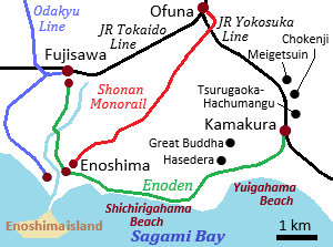
Map of Enoden
Train of Enoden
Enoden is a small railway running along the coast of Kamakura city.
The formal name is Enoshima Electric Railway, and the Japanese short name "Enoden" is well-known.
It connects JR Kamakura and JR Fujisawa stations and the length is about 10 km.
The train car is small and is like a streetcar.
The 3-km section from Kamakura staion is in the old town of Kamakura, so there are Hasedera temple and Great Buddha near the route.
The train runs along scenic Shichirigahama Beach and the passengers can see Enoshima island.
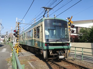
Hakone Tozan Railway
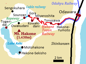
Map of Hakone Tozan Railway
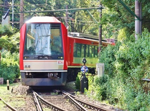
Train of Hakone Tozan Railway
Hakone Tozan Railway is a railway running from Odawara city to Gora in Hakone.
The length is 15 km, but the small trains climb an elevation difference of 527 meters.
Mount Hakone is a caldera volcano, and Gora is at the edge of the outer rim.
From Gora, a cable railway and a ropeway leads to Lake Ashi inside the caldera.
Along Hakone Tozan Railway, there is some hot spring areas such as Hakone-Yumoto, Tonosawa, Ohiradai, Miyanoshita, Kowakidani.
Odawara is a station of Shinkansen.
And, Odakyu Railway is operated the limited expresses from Shinjuku in Tokyo to Hakone-Yumoto.
Choshi Electric Railway
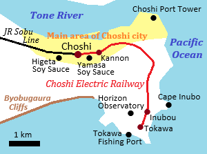
Map of Choshi Electric Railway
Train of Choshi Electric Railway
Choshi city is located about 100 km east of Tokyo, and is at the tip of the easternmost part of Kanto Region.
By JR limited express, it takes about 2 hours from Tokyo to Choshi.
Choshi Port's fish landings is one of the top classes in Japan.
And, there are the traditional soy sauce breweries.
Choshi Electric Railway is an old and small railway running in the city.
It departs from JR Choshi station, and the length is only 6.4 km.
The railway company is struggling.
So, it is generating various and unique ideas and is working hard to acquire passengers.
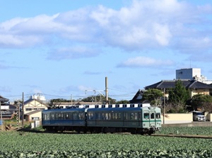
Chichibu Railway
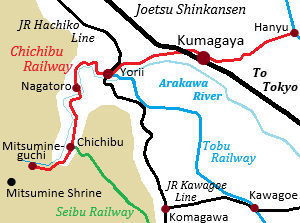
Map of Chichibu Railway
Train of Chichibu Railway crosses Arakawa River
Chichibu Railway is a railway running in the western part of Saitama Prefecture.
The line runs along Arakawa river and extends to the upper reaches of the river.
Arakawa river flows toward Tokyo and into Tokyo Bay.
Nagatoro gorge is the scenic spot.
The terminal station is Mitsumineguchi and there is sacred Mitsumine Shrine in the deep mountain.
Chichibu city is the center of the area and the old town.
There are some sightseeing spots.
Joetsu Shinkansen, Tobu Railway and Seibu Railway from Tokyo connect to this railway.
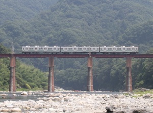
Watarase Keikoku Railway
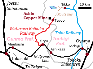
Map of Watarase Keikoku Railway
Train of Watarase Keikoku Railway
Watarase Keikoku Railway is a railway connecting Kiryu city in Gunma Prefecture and Mato in Nikko city.
The railway runs along the gorge formed by Watarase River.
The length is about 44 km.
("Keikoku" in the the name means "gorge".)
The sightseeing trains to view the scenery are operated.
The town near the end of the line is Ashio town.
There was Ashio Copper Mine which was the oldest and biggest in Japan and has the history from 1610 to 1973.
There is the sightseeing facility of the copper mine near Tsudo station.
From here, the route bus to Nikko is operated.
Railways for sightseeing in central Japan
Koshinetsu Region
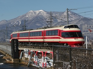
Mount Fuji
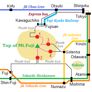
Railway map around Mt.Fuji
1) Kawaguchiko side 5th station
2) Fujinomiya side 5th station
3) Subashiri side 5th station
4) Gotenba side 5th station
Mount Fuji is located about 100 km west of Tokyo.
It is a symbol of Japan, and is a popular spot for international visitors.
Lake Kawaguchi, Lake Yamanaka, etc. are on the nothern foot of the mountain, and these form a resort area.
The area is in Yamanashi Prefecture.
JR Chuo Line runs from Tokyo, and Fuji Kyuko Railway runs to the area from Otsuki station.
The short name is "Fujikyu".
To Mount Fuji 5th Station, buses are operated.
The southern side of the mountain is in Shizuoka Prefecture.
The passengers in Tokaido Shinkansen and JR Tokaido Line can get a great view of a huge mountain from the train.
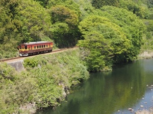
Nagano Electric Railway
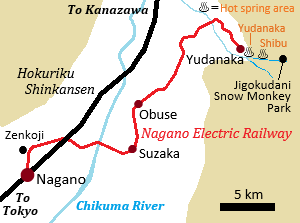
Map of Nagano Electric Railway
Train of Nagano Electric Railway
Nagano Electric Railway is a railway running from Nagano station to the eastern suburbs.
The length is about 33 km.
There is Obuse town which is a small old town, and the terminal station is Yudanaka.
There are Yudanaka and Shibu hot spring areas near Yudanaka station.
And, there is Jigokudani Snow Monkey Park in the mountains 3 km east from the onsen town.
That place is famous for wild monkeys that bathe in hot springs.
Ueda Electric Railway
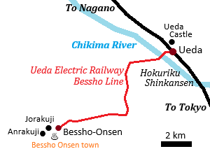
Map of Ueda Electric Railway
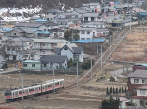
Train running near Bessho-Onsen station
Ueda is a small city located about 30 km south of Nagano city.
Ueda castle remains and there is the old town.
There is Ueda station of Hokuriku Shinkansen.
The trains of Ueda Electric Railway Bessho Line depart from the station.
The length of the railway is about 12 km and the line runs through a peaceful rural area.
The terminal station is Bessho-Onsen, and it is a small hot spring town.
There are a few Buddhist temples in the town.
Anrakuji has a three-story pagoda designated as a National Treasure.
Kamikochi Line
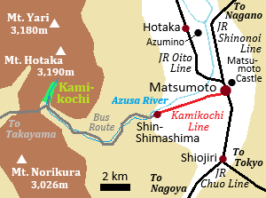
Map of Matsumoto and Kamikochi
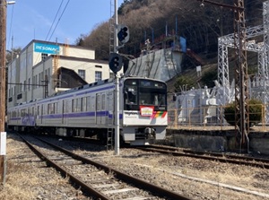
Train of Kamikochi Line
Kamikochi is the place with spectacular view of Northern Alps mountains.
For environmental conservation, using a car is not permitted in the area.
Matsumoto is the nearst city, and there is Kamikochi Line from Matsumoto station to Shin-Shimashima.
The railway company is "Alpico Kotsu" and the old name was "Matsumoto Electric Railway".
From Shin-Shimashima, the route bus is operated to the entrance of Kamikochi.
And, the route bus to Takayama city is also operated.
Hokuriku Region
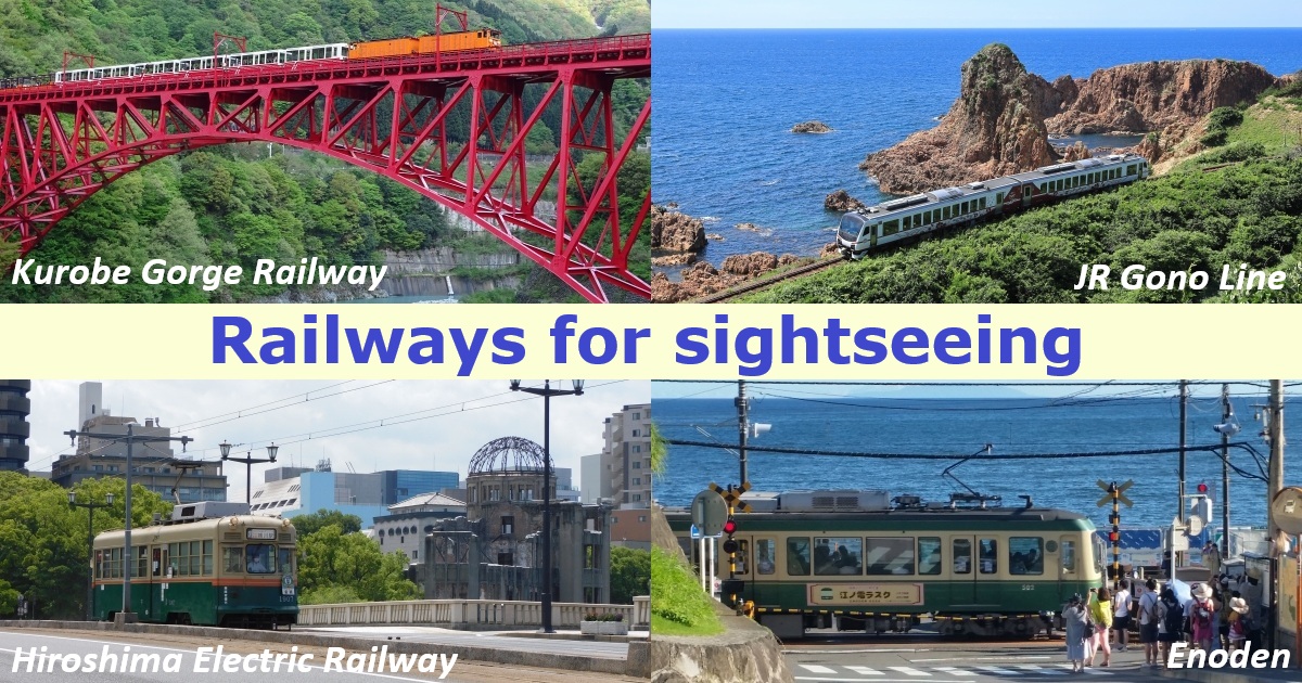
Toyama Chihou Railway & Kurobe Gorge Railway
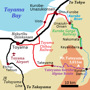
Railway map around Toyama city
Toyama city is a main city in Hokuriku Region.
Beautiful Tateyama Mountain Range lies just to the east of the city.
Tateyama Kurobe Alpine Route crossing the Tateyama mountain range is a world-class mountain sightseeing route.
Toyama Chihou Railway runs from Toyama station to the starting point of the route.
There is large Kurobe Dam on Tateyama Kurobe Alpine Route.
It is the dam upstream of the Kurobe River.
Kurobe River forms the deep gorge.
Toyama Chihou Railway runs from Toyama station to Unazuki Onsen town at the entrance of Kurobe Gorge.
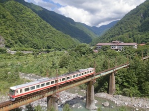
Train of Toyama Chihou Railway
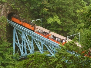
Train of Kurobe Gorge Railway
There is Kurobe Gorge Railway from Unazuki Onsen to the to the middle reaches of the river.
It is a private railway originally built for transporting materials for power plant construction.
Since 1971, the trolley trains have been operated for the toutists.
Noto Railway
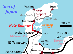
Map of Noto Railway
Train of Noto Railway
Noto Peninsula stretches into the Sea of Japan and occupies the northern half of Ishikawa Prefecture.
It is located far to the north of Kanazawa which is the capital city of Ishikawa Prefecture.
Wakura Onsen is a hot spring that gushes from the sea and is a popular hot spring resort in Noto area.
JR Nanao Line runs from Kanazawa to Wakura Onsen and limited expresses are operated.
From Wakura Onsen to Anamizu, Noto Railway runs along the coast.
The length is about 30 km.
From the car window, you can see the calm waters of Noto Bay and peaceful rural landscape.
From Anamizu, the route buses are operated to the main areas such as Wajima and Suzu cities in Noto Peninsula.
This area is in the process of recovering from the major earthquake that struck in January 2024.
Visiting Noto area will help support the recovery efforts.
Echizen Railway
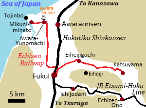
Map of Echizen Railway
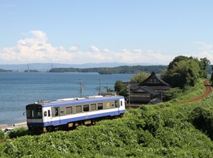
Train of Echizen Railway
Echizen Railway is a local railway which departs from Fukui station.
"Echizen" means the old name of this area.
Mikuni Awara Line connects Fukui and Mikuni-minato.
On the way, there is Awara hot spring resort.
Mikuni-minato terminal station is in a historical port town facing the Sea of Japan.
And, there is Tojinbo which is a scenic spot with steep cliffs near the town.
Katsuyama Eiheiji Line heads east from Fukui.
Eiheijiguchi station is the nearest station to Eiheiji temple which is a Zen temple where numerous monks undergo severe training.
And, Katsuyama terminal staion is popular for The Dinosaur Museum.
Tokai Region
Izukyu Railway & Izuhakone Railway
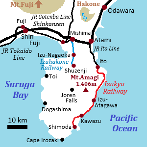
Railway map of Izu Peninsula
Izu Peninsula is located in eastern Shizuoka Prefecture.
The whole area is mountainous and many hot spring resorts are dotted throughout the peninsula.
It is also close to Hakone and Mount Fuji.
Izu is one of the popular resorts near the capital area.
There is a railroad line on the east coast.
Ito Line between Atami and Ito is a branch line of JR, and Izukyu Railway connects from Ito to Shimoda near the southern area of the peninsula.
JR limited expresses from Tokyo are opearated about one train per hour during the daytime, and many local trains are also operated.
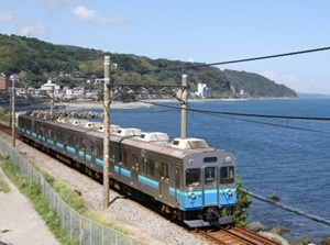
Train of Izukyu Railway
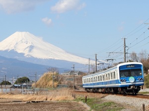
Train of Izuhakone Railway and Mt.Fuji
Izuhakone Railway is a 20km-long short railway line.
It connects Mishima city and Shizenji on the west side of the peninsula.
Shuzenji is a Zen Buddhist temple founded in the 9th century and it is said that the founded struck the hot spring.
So, the onsen town is the oldest in Izu Peninsula.
The local trains are operated frequently.
And, there are a few JR limited expresses from Tokyo.
Oigawa Railway
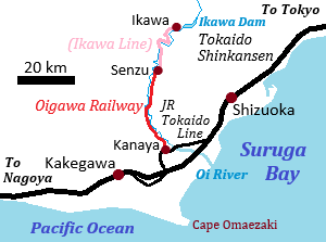
Map of Oigawa Railway
Oi River ("Oigawa" in Japanese) is a main river flowing from north to south in Shizuoka Prefecture.
"O" in the word is pronounced long as "Ōi".
Oigawa Railway runs along Oi River.
The main line is from Kanaya to Senzu located in the middle reaches, and the length is about 40 km.
From Senzu to Ikawa located upstream, there is Ikawa Line of the railway.
It was built for dam construction and the lenght is about 25 km.
It runs along steep and deep gorge, and it is Japan's only Abt rack railway.
This railway mainly operate the trains for tourists.
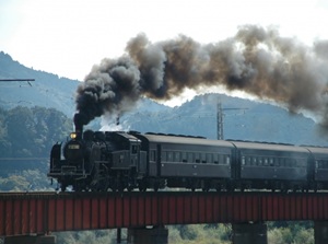
Train of Oigawa Railway by a steam locomotive
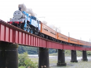
Thomas the Tank Engine
The train pulled by a steam locomotive in working order is popular.
And, for children, a few steam locomotives are disguised as "Thomas the Tank Engine" which is the popular character of a British children's television series "Thomas & Friends".
Kanaya terminal station is by a small station on JR Tokaido Line.
To visit this station, you get on the local train of JR Tokaido Line at Shizuoka or Kakegawa stations of Shinkansen.
Nagaragawa Railway
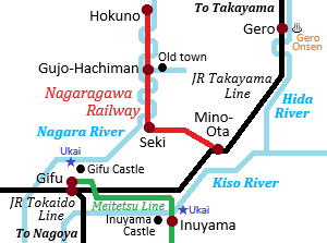
Map of Nagaragawa Railway
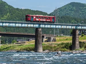
Train of Nagaragawa Railway
Nagara River ("Nagaragawa" in Japanese) flows in Gifu Prefecture and is known as the clear stream.
In Gifu city of the prefectural capital, there is Gifu castle, and Cormorant Fishing on the Nagara River is popular as the traditional performance.
Nagaragawa Railway runs through the middle reaches of Nagara River.
It departs from Mino-Ota staion of JR Takayama Line.
JR Takayama Line connects Nagoya, Gifu and Gero hot spring resort and Takayama city, and Mino-Ota is on the way.
The length is about 72 km.
Seki is known as a town of cutlery.
It is the 700-year-old center of Japanese sword production.
Gujo-Hachiman is another main town on this railway.
It is an old town with the castle and the clear streams of the river are used in daily life of the town.
Iga Railway
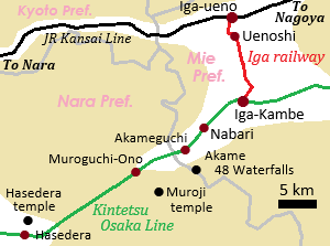
Railway map around Iga city
Train of Iga Railway with a picture of Ninja face
Iga city is located in a small basin in the western part of Mie Prefecture.
In the 16th century, Ninja were trained as mercenary or spy in this area.
Iga-Ueno area is the center of the city, and there are the castle and the facilities to know Iga Ninja.
Iga Railway runs through Iga-Ueno area.
The main station is Uenoshi, and the nickname of the station is "Ninja City station".
The railway connects Iga-Ueno station of JR Kansai Line and Iga-Kanbe station of Kintetsu Railway.
Iga-Ueno area is close to JR Kansai Line.
JR Kansai Line only has one train per hour.
Kintesu Line is the main line connecting Osaka and Ise area, Nagoya, so the trains are operated frequently.
Along Kintetsu Line around this area, there are the scenic spot such as Akame 48 Waterfalls and old Buddhist temples such as Moroji and Hasedera.
Railways for sightseeing in western Japan
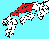
Kansai Region
Kobe city (神戸)
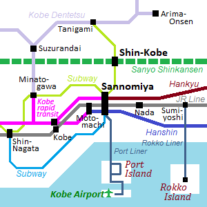
Railway map of Kobe city
Kobe is a large city located about 30 km west of Osaka city.
It has has a population of about 1.5 million.
The city has the history that the city had been developed as an international trade port after the opening of Japan to the world in 1868.
Kobe Port is the historic area and is the main sightseeing spot.
The Rokko Mountains lie just to the north of the city, and the city stretches long from east to west along the coast.
There is Arima Onsen which is one of the leading hot spring resorts in Kansai on the north side of the mountain.
In addition, Kobe Beef is famous worldwide.
Because the town is long from east to west, most railways also runs parallel to the east and west.
These are JR Tokaido Line, Hankyu Railway and Hanshin Railway from Osaka.
Sannomiya is the central station of them.
Shinkansen runs through tunnels in Rokko mountains and there is Shin-Kobe station in the mountain.
Kobe Subway connects Shin-Kobe and Sannomiya.
The tracks of Hankyu and Hanshin Railways go underground west of Sannomiya.
Both of them run on the line of "Kobe rapid transit".
The western side of it connects Sanyo Railway to Himeji, and the northern side connects to Kobe Railway to Arima Onsen.
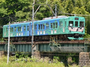
Wakayama Electric Railway
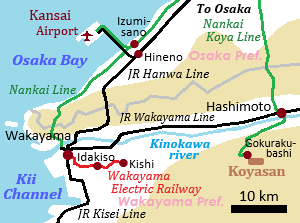
Railway map around Wakayama city
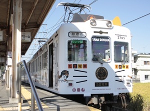
Cat-designed train of Wakayama Electric Railway
Wakayama Electric Railway is a small local railway about 14 km long.
It branches off from JR Wakayama station and runs through the countryside.
The terminal station is Kishi station.
A cat named "Tama" had kept as a pet in Kishi station.
In 2007, she was appointed the stationmaster of Kishi and became known all over the world.
She died in 2015, but the 3rd to 5th generation stationmasters work now.
They work in Kishi and Idakiso stations every day.
Kyoto Tango Railway
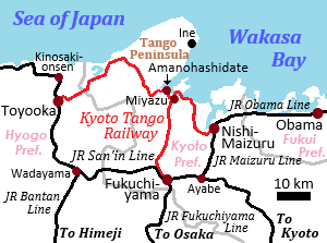
Kyoto Tango Railway
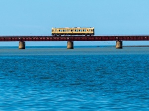
Train of Kyoto Tango Railway crossing Yura River
Kyoto Tango Railway is a railway running in the northern part of Kyoto Prefecture.
Kyoto city is the most popular city for foreign torists.
But Kyoto Prefecture extends to the Sea of Japan.
Amanohashidate is a scenic sandbar with beautiful pine trees, and has been counted as one of the three most beautiful landscapes in Japan since ancient times.
The railway has the lines to Amanohashidate.
There are the popular sightseeing towns such as Obama, Kinosaki hot spring around here.
There are also express trains running from Kyoto.
Chugoku Region
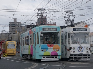
Okayama Electric Tramway
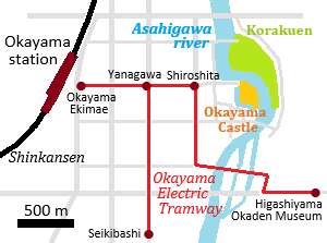
Map of Okayama Electric Tramway
Streetcars of Okayama Electric Tramway
Okayama Electric Tramway runs in the center of Okayama city.
The streetcars are operated and the total route length is only 5 km.
The popular sightseeing spots in Okayama city are Okayama Castle and Korakuen known for its beautiful Japanese gardens.
The streetcar departs from in front of JR Okayama station.
Shiroshita is the nearest streetcar stop and it takes 7 minutes from Okayama station.
The streetcar is opeareted frequently.
Streetcars of various colors and designs are in operation.
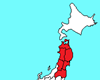
Hiroshima Electric Railway
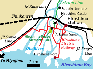
Railway map of Hiroshima city
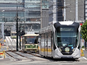
Streetcars of Hiroshima Electric Railway
Hiroshima is known as the first city in the world to have an atomic bomb dropped on it on August 6, 1945.
There are Atomic Bomb Dome and Hiroshima Peace Memorial Park in the center of the city, and the foreign torists visit there to think about what peace really means.
Hiroshima is a large city with a population of one million.
There is no subway, but there is the network of streetcar by Hiroshima Electric Railway.
The streetcars are operated from JR Hiroshima station to above spots.
And, it has the route to Miyajima with Itsukushima Shrine which is a National Treasure shrine floating on the sea.
Ichibata Electric Railway
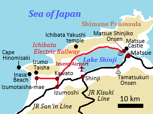
Railway map of Ichibata Electric Railway
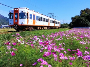
Train of Ichibata Electric Railway
Ichibata Electric Railway is a railway running in Shimane Prefecture.
Japanese name is "Ichibata-Densha", so the nickname is "Bataden".
It connects Matsue city, the prefectural capital, and the sacred Izumo Taisha Shrine in Izumo city.
The line runs through a peaceful, rural area along the northern shore of Lake Shinji.
The main line of JR in this region is San'in Line, and Bataden has a branch line to Izumoshi station of JR.
The trains run about once an hour.
You can enjoy views of Lake Shinji and idyllic rural scenery from the train window.
Shikoku Region
Kotoden
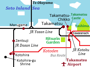
Railway map of Kotoden
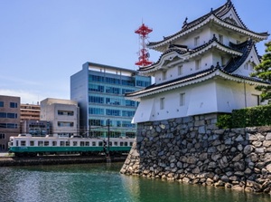
Kotoden running beside Takamatsu Castle
Kotoden is the railway running from Takamatsu city to the suburbs in Kagawa prefecture.
The formal name of the railway is "Takamatsu-Kotohira Electric Railroad", and "Kotoden" is its abbreviation.
As the name suggests, the route connecting takamatsu city and Kotohira town is the main line.
The terminal station is Takamatsu-Chikko and is near Takamatsu Port.
It is also close to JR Takamatsu Station.
There is Takamatsu Castle by the station.
On the way to Kotohira, there is Ritsurin Garden which is a Japanese garden designated as Special Place of Scenic Beauty.
In Kotohira town, there is Kotohira-gu Shrine.
It is one of Japan’s leading sacred spots.
Iyotetsu
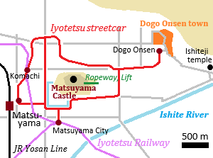
Railway map of Iyotetsu
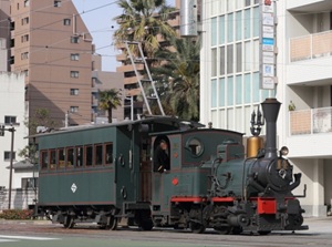
Botchan train of Iyotetsu
Iyotetsu is the railway running around Matsuyama city in Ehime Prefecture.
The formal name is "Iyo Railway", and "Iyo" is the ancient name of Ehime Prefecture.
There is "Matsuyama-shi" (Matsuyama City) station and four lines depart from there.
One of them is the line of streetcar.
There is a hill in the center of the city and Matsuyama Castle is on the top.
The streetcar runs around the hill.
And, a branch line leads to popular Dogo Onsen town.
For tourists, Botchan train is operated on the streetcar line.
"Botchan" written in 1906 is a beloved masterpiece of Japanese literature and one of the most popular, widely read novels in history.
Matsuyama city is the setting for the novel.
The train is designed to resemble the style of that era.
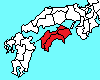
Kyushu Region
Fukuoka city (福岡)
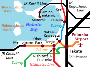
Railway map of Fukuoka city
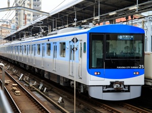
Subway of Fukuoka city
Fukuoka is the large city in Kyushu island.
It has has a population of about 1.6 million.
The name of the city is "Fukuoka", but the central station of JR is Hakata station.
Hakata area is the original main town in the city.
Shinkansen and many limited express trains to various destinations in Kyushu depart from here.
Three lines of subway are operated by Fukuoka City Transportation Bureau.
The main line is "Airport Line" and it connects Fukuoka Airport, Hakata station and the downtowns such as Tenjin and Nakasu.
Nishitetsu Railway is the main railway company.
(The formal name is "Nishi-Nippon Railroad".)
The terminal station is in Tenjin, and you can go to Dazaifu Tenmangu shrine and the old town Yanagawa by Nishitetsu.
Nagasaki Electric Tramway
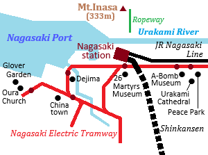
Railway map of Nagasaki Electric Tramway
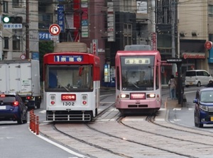
Streetcars in Nagasaki
Nagasaki is a historical city as only international trading port during the isolation period from 1639 to 1854.
And, Nagasaki is the second city to have an atomic bomb dropped on it after Hiroshima.
So, the city has the exotic atmosphere and the spots that convey the devastation of the atomic bombing.
Nagasaki Electric Tramway operate the streetcars in the center of Nagasaki city.
You can visit the sightseeing spots by the streetcar.
Kumamoto City Tram
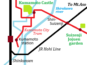
Railway map of Kumamoto City Tram
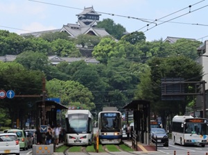
Streetcars running near Kumamoto Castle
Kumamoto Castle in Kumamoto city is one of the top-class Japanese castles.
Unfortunatle, it was heavily affected by the big earthquake in 2016. It is still in the process of recovering, but the castle reopened to the public in 2021.
Kumamoto City Tram is operated in the center of Kumamoto city.
By the streetcar, you can visit Kumamoto Castle and Suizenji Jojuen which was constructed as the Jpanese garden by the lord of the castle in 1671.