
Mountains and Lakes in Japan


About mountains in Japan
Northern Alps from Kamikochi
Crater of Mt.Aso volcano
Japan is a mountainous country.
In addition, there are many volcanoes because Japanese islands are on a part of the belt of volcanoes in the Pacific Ocean called "Ring of Fire".
Most lakes are dotted in the mountain and they are not so large.
Many of them were formed by volcanic activity and they are almost "caldera lake" that water has collected around the volcano.
There are many scenic mountains throughout Japan.
In the cold season, snow covers the high mountains.
The scenery is beautiful and divine.
Some mountains have been worshiped as god since ancient times, so there are sacred Shinto shrines and Buddhist temples.
And, some mountains have onsen resorts.
In addition, popular ski resorts are around some mountains.
Mountains and lakes are also good sightseeing spots.
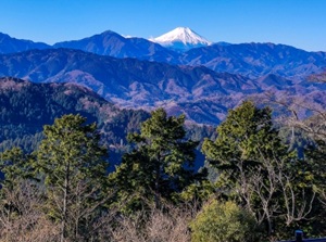
Mount Fuji
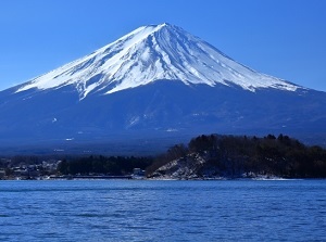
Mt.Fuji from Lake Kawaguchi
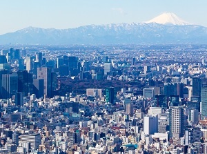
Mt.Fuji from Tokyo
Mount Fuji is the most famous mountain in Japan and is called "Fujisan" (富士山) in Japanese.
Mount Fuji is the highest mountain in Japan.
Its altitude is 3,776 meters and is located about 100 km west of Tokyo.
It is a volcano but the last eruption was over 300 years ago.
The beautiful and majestic figure has been a subject of faith since ancient times.
Mount Fuji is a spiritual home of all Japanese people.
The northern foot of Mt.Fuji is a resort area with five lakes and we can see the excellent scenery closely.
The roads for bus and car lead to the fifth station.
The tourist can go there.
Only in July and August, climbing to the top is allowed.
To climb Mt. Fuji, climbers pay 4,000 yen as climbing fee.
Only 4,000 climbers are allowed the climbing in a day.
And, the climber need to a suitable equipment.
It takes at least 6 hours to climb to the top, so it takes over 10 hours to come back to the foot.
The temperature on the top is around 6 to 8 degrees C in summer.
The weather changes sometimes.
Because the height is over 3,000 meters, half of the climbers get altitude sickness.
Foreign tourists are increasing recently.
But careless, reckless and mannerless climber appears sometimes.
If you want to climb, you should prepare the suitable equipment and schedule.
In addition, take your garbage with you and don't pollute the natural environment.
Mountains and lakes in eastern Japan
Hokkaido Region
Niseko (ニセコ)
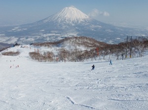
Mt. Yotei from a ski resort in Niseko
Niseko is a popular ski resort around Mount Niseko-An'nupuri (1,308 m) and some peaks.
This area has been the quasi-national park and ski resorts have been developed since the 1960s.
Australian skiers made Niseko more popular from around 2000, so it is just like a foreign resort town now.
From Niseko, we can see beautiful Mount Yotei (羊蹄山, 1,898 m) like Mt.Fuji.
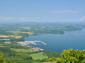
Lake Shikotsu (支笏湖)
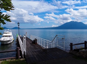
Lake Shikotsu is a caldera lake by eruption of volcano.
It is located about 30 km south of Sapporo city, and is located about 20 km west of Shin-Chitose Airport.
There are three active volcanos near this lake.
This lake doesn't freeze in winter.
Lake Toya (洞爺湖)

Lake Toya
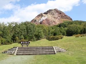
Showa-shinzan
Lake Toya is a scenic caldera lake by eruption of volcano.
It is located about 35 km west-southwest of Lake Shikotsu.
The shape of the lake is almost circular and there is an island in the center.
There is the onsen town on the lakeside.
Around the lake, there are an active volcano Mount Usu (有珠山, 737 m) and a new volcano Showa-shinzan (昭和新山, 398 m) which appeared suddenly from 1943 to 1945.
Onuma (大沼)
Onuma is a quasi-national park of Japan near Hakodate city at the southern end of Hokkaido.
There is Komagatake volcano (1,131 m) in the center of the area.
The volcano is active and has erupted sometimes.
Lake Onuma and a few small lakes are around the volcano.
There is rich nature there.
Daisetsuzan (Taisetsuzan) (大雪山)
Asahidake peak of Daisetsuzan
Daisetsuzan is a group of some volcanoes in the center of Hokkaido, and is also called "Taisetsuzan".
It is located about 45 km east of Asahikawa city.
The highest peak is 2,291 meters high and many peaks make a large group of the mountain.
A steep gorge Sounkyo is on the north side and there is onsen town.
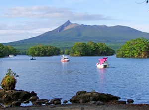
Lake Akan (阿寒湖)
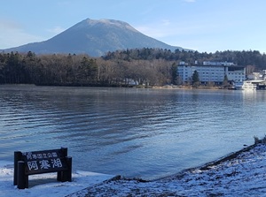
Lake Akan is a caldera lake and is located about 60 km north of Kushiro city in the eastern part of Hokkaido.
It is at the foot of two volcanoes.
The lake is famous for "Marimo" which is a spherical moss.
There are the onsen town and the village of Ainu people.
Lake Mashu (摩周湖)
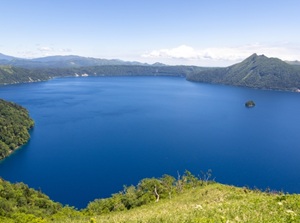
Lake Mashu is a caldera lake and is located about 50 km south-southeast of Abashiri city.
The lake is surrounded with high cliffs, so we can't get any closer to the lakeside.
The clarity of the water is the best in Japan.
So the water color is beautiful and mysterious blue.
Lake Kussharo (屈斜路湖)
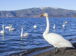
Lake Kussharo is also a caldera lake near Lake Mashu and it is on the the biggest caldera lake in Japan.
It located about 15 km west of Lake Mashu.
It has acidic water, so few fish are living in this lake.
But, this lake is in a caldera, so there are hot springs here and there on the lakeside.
In winter, many swans come around this area.
Lake Saroma (サロマ湖)
Lake Saroma is the largest lake in Hokkaido and faces Okhotsk Sea.
It is located about 30 km west of Abashiri city.
The long and narrow sand bank separates the lake from the Okhotsk Sea.
The boundless scenery is quite different from taraditional Japan.
Lake Shikaribetsu (然別湖)
Lake Shikaribetsu is a lake in the mountain to the west of Obihiro city.
It is surrounded by the mountains as much as 1,000 meters high, and no private home is around this lake.
There is a hot spring resort with two hotels at the southwestern lakeside.
We can see only the buildings of these hotels.
The lake freezes in winter and the event by houses made of ice blocks on the lake is held.
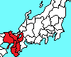
Tohoku Region
Hakkoda (八甲田, Aomori Pref.)
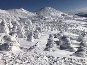
Hakkoda in winter
Hakkoda is a group of volcanoes, and the highest peak is 1,584 m high.
It is located about 30 kmsouth of Aomori city.
The highland around the mountain is not so steep.
Much snow falls in winter, and we can see rime ice.
There is a primitive Onsen resort, Sukayu Onsen.
Lake Towada (十和田湖, Aomori Pref.)
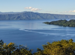
Lake Towada
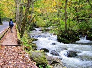
Oirase stream
Lake Towada is a caldera lake, and it is located to the south of Hakkoda.
The lake is surrounded with forest, so the scenery is beautiful.
Oirase stream flows into the lake.
Many streams, waterfalls are seen along a river.
It is also a popular sightseeing spot.
Shirakami-Sanchi (白神山地, Aomori & Akita Prefs.)
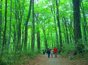
Shirakami-Sanchi is a mountain area, and the primeval forests are 130,000 hectares in area between Aomori and Akita Prefectures.
Old beech forests extend on the mountains, and it is designated a World Heritage Site.
As the valuable forests are main, there are few grand or wonderful sceneries as sightseeing spot.
Hachimantai (八幡平, Iwate Pref.)
Hachimantai is a group of volcanoes, and the highest peak is 1,613 m high.
It is located between Iwate and Akita Prefectures.
Shapes of the mountains are gentle, so it is like a highland.
Countless ponds and marshes are dotted around the mountain.
And, there are some small onsen village and ski resorts.
Ryusendo (龍泉洞, Iwate Pref.)
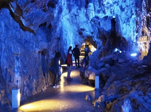
Ryusendo is one of the most famous limestone caves.
It is in the mountains of Iwaizumi town in the eastern part of Iwate Prefecture.
The water of underground lakes has the world's top clarity.
The explored part of cave is over 2.5 km long.
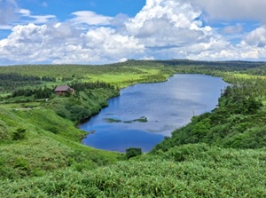
Lake Tazawa (田沢湖, Akita Pref.)
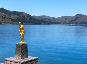
Lake Tazawa is a small round lake about 6 km in diameter.
It is located about 70 km east of Akita city.
It is the deepest lake in Japan and the depth is 423 meters.
The deep blue color of the water is attractive.
There is a legend that a beautiful girl became a dragon, and the statue by the lake is the symbol.
Mount Zao (蔵王, Yamagata & Miyagi Prefs.)
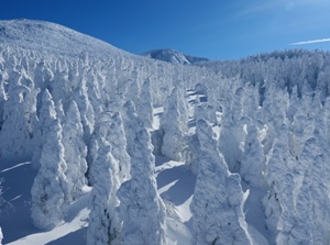
Mount Zao in winter
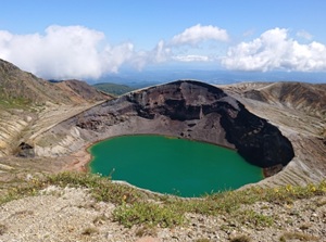
Okama
Mount Zao is a group of many volcanoes between Yamagata and Miyagi Prefectures.
The highest peak is 1,841 meters high.
The mountains have some scenic spots and hot springs.
Rime ice in winter is very famous, and the ski resort is also popular.
There is a popular crater lake Okama on the east side.
Three sacred mountains of Dewa (出羽三山, Yamagata Pref.)
Mount Gassan of three sacred mountains of Dewa
Three sacred mountains of Dewaare dotted in the center of Yamagata Prefecture.
These are Mt.Haguro, Mt.Gassan and Mt.Yudono.
It is said that a prince performed the ascetic practices in the 6th century, so many mountain priests perform the ascetic and hard practices strolling in these mountains for over a week in early autumn.
Tourists can visit the Shinto shrines in each mountain.
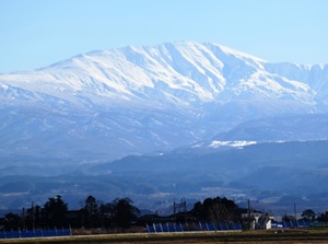
Mount Bandai (磐梯山, Fukushima Pref.)
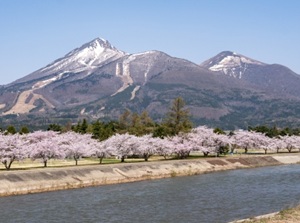
Mount Bandai
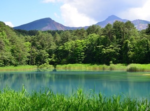
A lake in Ura-Bandai
Mount Bandai is a volcano 1,816 meters high.
It is located in the center of Fukushima Prefecture.
By the great eruption occured in 806, the volcano like Mt.Fuji became a mountain without the top.
There is Lake Inawashiro at the southern foot of the mountain.
And, some lakes are dotted at the northern foot and the scenic area is called Ura-Bandai.
Lake Inawashiro (猪苗代湖), Fukushima Pref.)
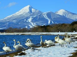
Swans in Lake Inawashiro and Mt. Bandai
Lake Inawashiro is located about 15 km east of Aizu-Wakamatsu city.
It is at the southern foot of Mt. Bandai, so it is a scenic place to see the mountain.
The water of lake had been very acid under the influence of the volcanos, but it is closer to neutral water now.
In winter, many swans come flying on the north and east shore of the lake.
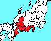
Kanto Region
Takaosan (高尾山, Tokyo Metropolis)
View of Mt. Fuji from the top of Mt. Takao
Takaosan (Mount Takao) is a mountain 599 meters high.
It is located about 50 km west of central Tokyo.
It is a popular mountain to go hiking, so many people visit here throughout the year.
A commuter railway connects to central Tokyo and it takes only 1 hour by train.
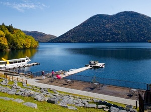
Hakone (箱根, Kanagawa Pref.)
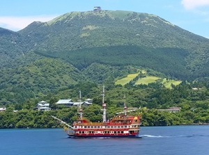
Mt. Hakone and Lake Ashi
Hakone is the area in a caldera volcano.
It is a well-known onsen area close to Tokyo and is near Mount Fuji.
Several onsen districts are dotted in the caldera.
And there is scenic Lake Ashi, so Hakone is a wide sightseeing spot.
Tsukubasan (筑波山, Ibaraki Pref.)
Tsukubasan (Mount Tsukuba) is the only mountain in wide Kanto Plain.
The highest peak is 877 m high.
It has been the object of mountain worship since ancient times and there are a few shrines on the mountain.
Ropeway and cable car to the peaks are operated.
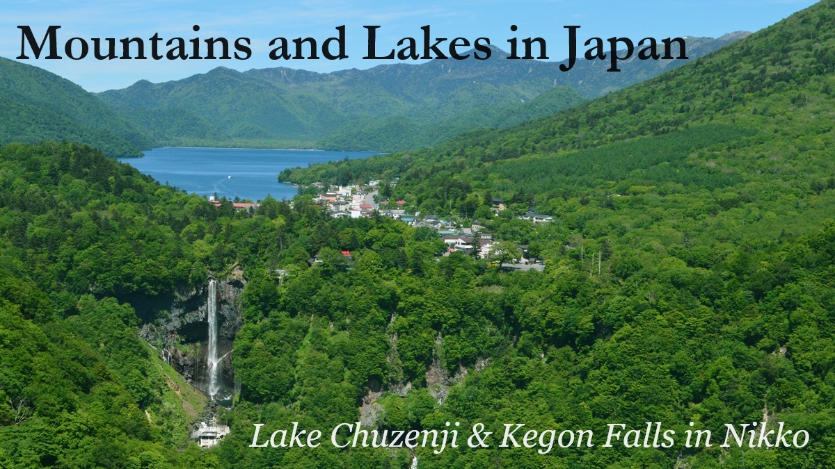
Lake Chuzenji (中禅寺湖, Nikko city, Tochigi Pref.)
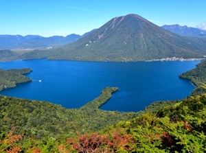
Lake Chuzenji
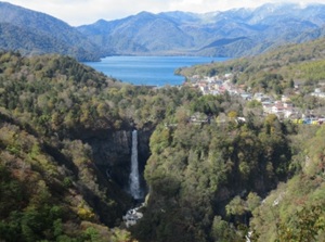
Kegon Falls and Lake Chuzenji
Lake Chuzenji is a dammed lake by the eruption of Mt.Nantai.
It is located to the west of sacred city Nikko.
There is famous Kegon Falls at the place that a river flows out from the lake.
The river flows down to the main area of Nikko city.
Guide to Lake Chuzenji Guide to Kegon Falls
Tanigawadake (谷川岳, Gunma Pref.)
Tanigawadake (Mount Tanigawa) is a mountain on the dividing ridge of Honshu island.
It is located between Gunma and Niigata Prefectures.
The highest peak is 1,977 m high.
It is one of the popular mountains for alpinist, and there are some steep cliffs for rock climbers.
For general tourist, there are a few observatories around the mountain.
Asamayama (浅間山, Gunma & Nagano Prefs.)
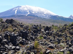
Mount Asama from Onioshidashi
Asamayama (Mount Asama) is an active complex volcano, and the volcanic activity is still continuing.
Karuizawa resort town is at the southern foot.
There is Onioshidashi to the northern foot of the mountrain.
We can see the real lava field erupted in 1783.
Mountains and lakes in central Japan
Koshinetsu Region
Yatsugatake (八ヶ岳, Yamanashi & Nagano Prefs.)
Yatsugatake is a group of mountains located on the prefectural border between Yanamashi and Nagano.
The highest peak is 2,899 m high.
There are some popular resort areas such as Kiyosato and Tateshina around the foot of the mountains.
Echigo-Yuzawa (越後湯沢, Niigata Pref.)
Echigo-Yuzawa is a mountain area on the western side of Mount Tanigawa.
It is in a heavy snowfall area in winter, so some popular ski resorts are dotted.
If you want to see the snow in Japan, Echigo-Yuzawa is a good town between mid-December and early March.
Because, Shinkansen trains lead to you within only 1.5 hours from Tokyo.
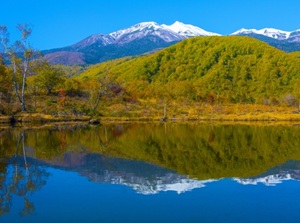
Myokosan (妙高山, Niigata Pref.)

Myokosan (Mount Myoko) is an active volcano, and it is 2,454 m high.
It is located about 30 km north of Nagano city.
It is one of beautiful mountains in Japan.
It is called as "Echigo-Fuji" meaning mount Fuji in Niigata Prefecture.
There are some onsen resorts and ski resorts on the eastern slope.
Togakushiyama (戸隠山, Nagano Pref.)
Togakushiyama (Mount Togakushi) is a rocky mountain located about 20 km northwest of Nagano city.
It is at an altitude of 1,904 meters.
Since ancient times, it was a place to perform the ascetic practices.
There are some shrines along the climbing road to the top.
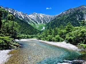
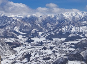
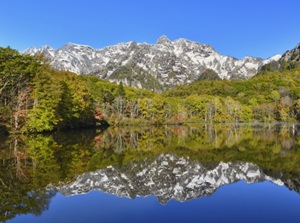
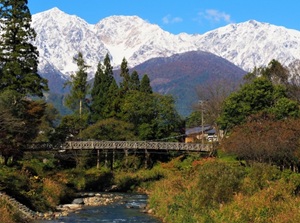
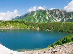
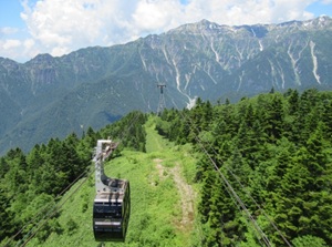
Northern Alps and Kamikochi (上高地, Nagano Pref.)
Mountains of Northern Alps
Mt. Hotakadake from Kamikochi
Northern Alps is a mountain range along the northwest border of Nagano Prefecture.
It is a huge wall blocking between the easten and western Japan.
There are many peaks 2,000 to 3,000 meters high.
These are the highest mountains in Japan.
Yarigatake (槍ヶ岳, 3,180 m), Hotakadake (穂高岳, 3,190 m), Tsurugidake (剱岳, 2,999 m), Shiroumasake (白馬岳, 2,932 m), etc. are the main peaks.
They are popular with alpinists, and there are some resorts around them.
Kamikochi is a scenic valley around Hotakadake in Northern Alps.
It is an entrance place to Hotakadake, and general tourists can visit there.
Norikura Highland (乗鞍高原, Nagano Pref.)
Norikura Highland is the area on the east slope of Norikuradake (3,026 m) in the south part of Northern Alps.
It is located about 15 km south of Kamikochi.
The mointain is not steap and a bus route is set up around the mountain.
There are some waterfalls and ponds, and Shirahone onsen resort is popular.
Hakuba village (白馬村, Nagano Pref.)
Hakuba village is a village around the foot of Shiroumadake and Yarigatake in the north part of Northern Alps.
It is located about 60 km north of Matsumoto city.
It was a venue for the Nagano winter Olympics in 1988.
So, there are some popular ski resorts.
Ontakesan (御嶽山, Nagano & Gifu Prefs.)
Ontakesan is an active volcano and the highest peak is 3,067 m high.
It is located about 80 km northeast of Nagoya city.
There are an onsen resort and some ski resort around the mountain.
The northeastern foot has relatively-gentle slope, so it is called Kaida highland.
IT is known as a production center for traditional "Kiso-pony".
Ther volcano erupted in 2014, and 58 climbers around the top fell victim to the eruption.
Kiso-Komagatake (木曽駒ヶ岳, Nagano Pref.)
Kiso-Komagatake is a steep mountain and the altitude is 2,956 meters.
It is one of the mountains in "Central Alps" and is located about 30 km east of Ontakesan.
The cirque by glacial erosion is attractive.
A ropeway is operated to the bottom of the cirque.
Hokuriku Region
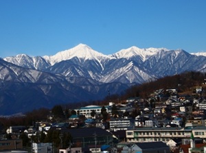
Tateyama Kurobe Alpine Route (Toyama Pref.)
Tateyama mountains from Toyama city
Murodo-daira plateau near the top of Tateyama
Tateyama Kurobe Alpine Route is a popular sightseeing route crossing the Northern Alps from west to east.
It connects Toyama city in Toyama Prefecture and Omachi city in Nagano Prefecture.
The route passes beautiful Mount Tateyama (立山, 3,015 m) and huge Kurobe Dam.
There is no connecting road, so the tourists must use cable car, ropeway, special bus.
Guide to Tateyama Kurobe Alpine Route
Hakusan (白山, Ishikawa, Fukui & Gifu Prefs.)
Hakusan is a volcano and the highest peak is 2,702 m high.
It is located about 50 km south of Kanazawa city.
Hakusan means "White mountain", because snow covers the mountain for a long period a year.
Since ancient times, it has been a popular mountains to worship.
There is an old shrine, and waterfalls and hot spring are dotted around the mountain.
Mikata-goko (三方五湖, Fukui Pref.)
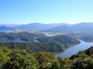
Mikata-goko is a group of five small lakes facing Wakasa Bay.
It is located about 20 km west of Tsuruga city.
All lakes are connected with a narrow channel or a canal.
The shape of the lake is complicated and the hills between the lakes make the appearnce of beautiful scenery.
A scenic road is set up and a pleasure boat is operated.
Tokai Region
Nihondaira hill (日本平, Shizuoka Pref.)
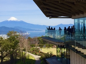
The observatory on the top of Nihondaira
Nihondaira hill is a hill near Shizuoka city.
It is at an altitude of 307 meters.
There is Kunozan Toshogu shrine enshrining Tokugawa Ieyasu at the southern foot of the hill.
The top is a park with a few observatories.
Here is one of good places where the good view of Mt. Fuji is seen.
Lake Hamana (浜名湖, Shizuoka Pref.))
Kanzenji onsen resort by Lake Hamana
Lake Hamana is a lake near Hamamatsu city in Shizuoka Prefecture.
It is near the Pacific Ocean and the southern end connects with the sea.
There are onsen resort and historic spot, and the farm raised eels around the lake are the speciality.
Tokaido Shinkansen runs on the lakeside, so the passengers can see the lake.
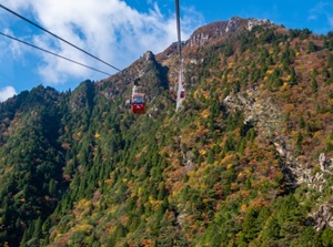
Oku-Hida Onsen village (奥飛騨温泉郷, Gifu Pref.)
Northern Alps and Shin-Hotaka Ropeway
Oku-Hida Onsen village is an onsen areaon the western side of the mountains of Northern Alps.
It is located about 30 to 40 km east of Takayama city.
There are five onsen villages in the steep valleys near the mountains.
There is the observatory to see beautiful Hotakadake in Norther Alps and Shin-Hotaka Ropeway is operated.
Guide to Oku-Hida Onsen village
Gozaishodake (御在所岳, Mie Pref.)
Gozaishodake (Mount Gozaisho) is a rocky mountain.
It is at an altitude of 1,212 meters.
It is located about 20 km west of Yokkaichi city in Mie Prefecture and is about 50 km from Nagoya city.
Rime ice of this mountain in winter is rare in this warm region and there is even a small ski slope.
There is Yunoyama onsen town on the eastern slope of the mountain.
Mountains and lakes in western Japan
Kansai Region
Lake Biwa (琵琶湖, Shiga Pref.)
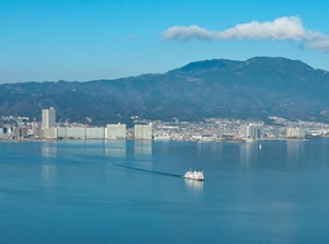
Otsu city & Mt. Hiei by Lake Biwa
Lake Biwa is the largest lake in Japan.
The lenght from north to south is about 80 km, and the length at the widest part from east to west is about 25 km.
It occupies the wide area of Shiga Prefecture.
There is Otsu city at the southern end of the lake and Kyoto city is located just west of Otsu.
In the ancient time, Lake Biwa was a route of water transportation to Kyoto.
And the main roads from Edo (Tokyo) to Kyoto passed around the lake.
So, some old towns are dotted near Lake Biwa.
Hieizan (比叡山, Shiga & Kyoto Prefs.)
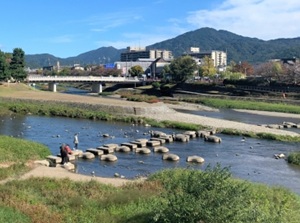
Mount Hiei from Kamo River in Kyoto
Hieizan (Mount Hiei) is a mountain between Kyoto city and Otsu city facing Lake Biwa.
It is at an altitude of 848 meters.
There is a large Buddhist temple Enryakuji near the peak.
The mountain is the site of the temple, so it is a sacred ground.
The visitors can visit from both Kyoto and Otsu.
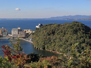
Rokkosan (六甲山, Hyogo Pref.)
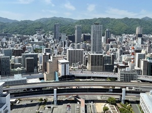
Mount Rokko and Kobe city
Rokkosan (Mount Rokko) is a mountain range just north of city area in Kobe.
It is at an altitude of 931 meters.
The mountain lies east and west for 30 km, so the main area of Kobe city is narrow and long along the foot of the mountain.
There are some observatories around the top.
It is said that here is one of the major night views in Japan.
Wakakusayama (若草山, Nara Pref.)
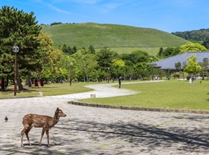
Wakakusayama is a low mountain like a hill on the east side of Nara city.
It is at an altitude of 342 meters.
There are Todaiji temple and Kasuga-taisha shrine at the foot of mountain, and the top has a fine view of the ancient city.
There are the wild deer, the symbol of Nara city, in the mountain.
Yoshinoyama (吉野山, Nara Pref.)
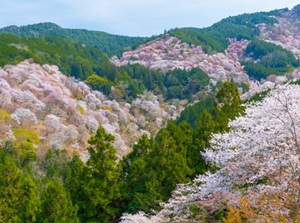
Many cherry trees in Yoshinoyama
Yoshinoyama is the mountains in the center of Nara Prefecture.
It is located about 40 km south of Nara city.
The area has been a sacred ground and some temples and shrines are dotted.
Since ancient times, cherry trees had been planted in the mountain.
So, there are 30,000 cherry trees in the wide area of the mountains now.
This is the Japan's largest place famous for its cherry blossoms.
The season is from late March to late April.
Chugoku Region
Washuzan (鷲羽山, Okayama Pref.)
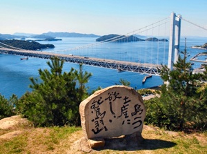
The view from an observatory on Mt. Washu
Washuzan (Mount Washu) is a small mountain by the Seto Inland Sea, and is located about 30 km south of Okayama city.
It is at an altitude of 133 meters.
From the observatory, visitors can the scenary of Seto Inland sea with many islands and the bridge connecting Shikoku Island.
Daisen (大山, Tottori Pref.)
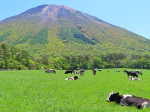
Mount Daisen is a large volcano and the highest peak is 1,729 meters high.
It is located about 20 km east of Yonago city in the western part of Tottori Prefecture.
The shape is similar to Mt. Fuji, so Daisen has been worshipped as a god since ancient times.
There are a few temples and shrines around the mountain.
Lake Shinji (宍道湖, Shimane Pref.)
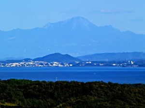
Lake Shinji, Matsue city, and Mt. Daisen
Lake Shinji is a brackish lake, and it stretches to the west of Matsue city, the capital of Shimane Prefecture.
Shijimi clam in Lake Shinji is well-known.
And 7 different kinds of the fish including Shijimi in the lake are used for the local dishes in this area.
The view of sunset in Matsue is also popular.
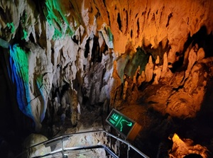
Akiyoshidai (秋吉台, Yamaguchi Pref.)
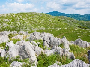
Akiyoshidai
Akiyoshido cave
Akiyoshidai is the widest karst tableland in Japan.
It is located to the west-northwest of Yamaguchi city.
We can see the undulating karst landscape dimpled with many dolines and countless limestone pinnacles up to 2 meters in height.
There is Akiyoshido limestone cave under Akiyoshidai.
A course about 1 km long is opened to the public.
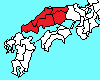
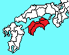
Shikoku Region
Godaisan (五台山, Kochi Pref.)
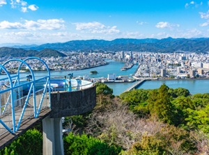
The view of Kochi city from Godaisan
Godaisan (Mount Godai) is a small mountain by Kochi Port.
It is at an altitude of 146 meters.
It is a popular observatory of Kochi city.
There is Chikurinji temple with a beautiful five-story pagoda.
It is the 31st temple of "88 temples of Shikoku Pilgrimage", so many pilgrims visit here.
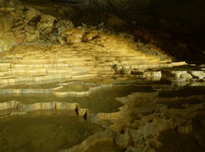
Ryugado (龍河洞, Kochi Pref.)
Ryugado is one of the most famous limestone caves.
It is located in the mountains about 20 km east of Kochi city.
The total length of the cave is about 4 km, and the part about 1 km long is open to the public.
A ruin of dwelling place in primitive age were discovered in the cave.
The explored part of cave is about 1 km long.
Kyushu Region
Unzen (雲仙, Nagasaki Pref.)
Myokendake peak in Unzen in autumn
Unzen is an active volcan group and is located in a peninsula about 40 km east of Nagasaki city.
Some peaks are dotted and the highest peak is 1,483 meters high.
It erupts sometimes, but it has been a tourist resort since ancient times.
There are onsen town and sightseeing spots around the mountain.
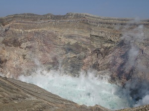
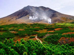
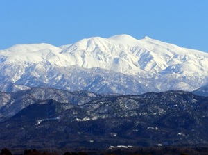
Mount Aso (阿蘇山, Kumamoto Pref.)
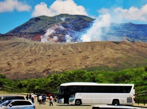
The crater of Mount Aso
Mount Aso is one of the world's largest caldera volcano.
It is located about 40 km east of Kumamoto city.
There is a large central cone and the highest peak is 1,592 m high.
And the outer rim about 18 to 25 km across surrounds the caldera.
In the large crater, there are some sightseeing spots.
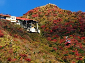
Mount Kirishima (霧島山, Miyazaki & Kagoshima Prefs.)
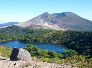
Karakunidake peak of Mount Kirishima
Mount Kirishima is a group of active volcanoes, and has many peaks.
It is located about 60 km west of Miyazaki city and about 50 km northeast of Kagoshima city.
Karakunidake peak is the highest peak and is 1,700 meters high.
There are some small lakes around the peak.
Ebino Plateau is on the northeastern slope.
And there is Kirishima-jingu shrine enshrining the mountain on the southwestern foot.
Guide to Ebino Plateau Guide to Kirishima-jingu
Sakurajima (桜島, Kagoshima Pref.)
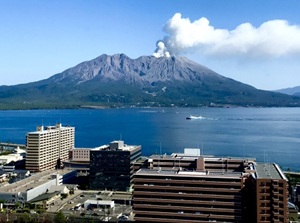
Sakurajima from the center of Kagoshima city
Sakurajima is an active volcano and is 1,117 m high.
It stands just in front of central Kagoshima city.
It often erupts and volcanic ash falls on the city sometimes.
It is said that the scenery of the volcano and the city is similar to Naples in Italy.
Yakushima (屋久島, Kagoshima Pref.)
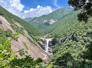
Mountains in Yakushima
Yakushima is an island located about 150 km south of Kagoshima city.
The shape of the island is round about 24 to 28 km across.
The whole area is mountainous and there is the hightest mountain is 1,936 meters high.
The forest covered all over the mountains and the island has rich nature.
It was designated a UNESCO World Natural Heritage site.