
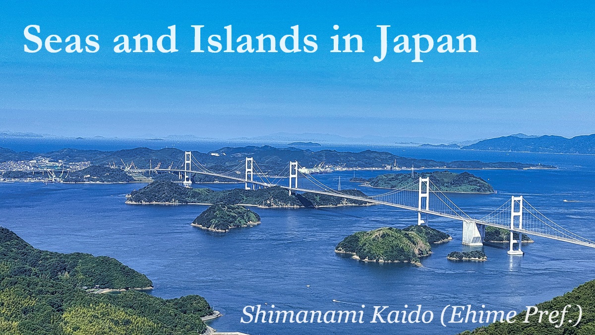
Seas and Islands in Japan
Japan is an island country.
The mainland consists of four large island, and small islands are dotted around the mainland.
Total number of the islands in Japan is 14,125, and people live in 416 islands of them.
The land area is not so large, but the total length is the sixth longest in the world.
There are various scenic spots and resort areas of sea throughout Japan.
Seas and Islands in each region
Hokkaido Tohoku Kanto Koshin-etsu Hokuriku Tokai Kansai Chugoku Shikoku Kyushu
Seas and Islands in Hokkaido Region
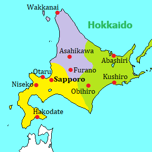
Cape Soya (宗谷岬) is the northernmost cape in Japan.
It is a cape, but there is the shore and wide grassland extends around the cape.
From the cape, you can see Sakhalin Island in Russia.
Rishiri Island (利尻島) is an island near Wakkanai city.
There is a volcano Mt.Rishiri in the center of the island, and whole island is full of nature.
Rebun Island (礼文島) is an island next to Rishiri Island.
The scenery of the coast and small lake are popular.
Drift ice (Ryuhyo) comes ashore around the northeastern coast of Hokkaido from late January to early March.
The cruising ships are operated from Abashiri city and Monbetsu cities.
Shiretoko Peninsula (知床半島) is a long peninsula extending about 70 km toward northeast like a horn and is registered as a World Natural Heritage Site.
It is covered with primary forests and people is living only in a few villages on the coast part near the mainland.
Notsuke Peninsula (野付半島) is the biggest sand spit in Japan.
You can see the unique sceneries such as the fields of blighted primeval forest and wild flowers.
Cape Nosappu (納沙布岬) is the easternmost place of Japan where the common tourists can visit.
We can see the islands occupied illegally by Russia (former Soviet Union) in 1945.
Cape Erimo (襟裳岬) is a sharp corner at the center of bottom on a map of Hokkaido, and it is the place that Hidaka Mountain range falls into the Pacific Ocean directly.
It had become popular by a Japanese popular song in 1974.
Cape Chikyu (地球岬) is located south of urban area of Muroran city.
It is the northern entrance of Uchiura Bay and the east side faces the Pacific Ocean.
When we look at the horizon there, we realize that the earth is round.
Shakotan Peninsula (積丹半島) is a mountainous peninsula extending from the west of Otaru city to the northwest.
Various scenic spots are along the coastline, and the color of the sea is beautiful.
Okushiri Island (奥尻島) is a small island to the southwest of Hokkaido.
There is no bear, fox and venomous snake in this island, so here is a paradise for hares, raccoon dogs, common pheasant, etc.
Sea Urchin, abalone, squid are the tasty specialty of this island.
Seas and Islands in Tohoku Region
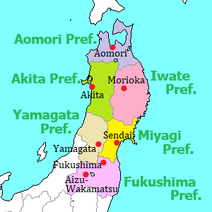
Hotokegaura (仏ヶ浦, Aomori Pref.) is a part of west coast of Shimokita peninsula shaped like an ax.
It faces Tsugaru Strait between Hokkaido and Honshu islands, and there are white uniquely shaped rocks and cliffs along the coast.
Cape Tappi (竜飛崎, Aomori Pref.) is at the north tip of Tsugaru Peninsula facing Tsugaru Strait.
Just under this cape, there is Seikan Undersea Tunnel connecting Aomori and Hokkaido.
JR Gono Line (五能線) is a local railway of JR and t connects Hirosaki in Aomori Prefecture and Noshiro in Akita Prefecture (about 147 km).
The trains run along the scenic coastlines, so it is popular for tourists.
Sanriku Coast (三陸海岸, Iwate Pref.) is the coast of Iwate Prefecture, and it faces the Pacific Ocean.
The whole area is very steep and high cliffs are dotted.
There are some popular sightseeing spots in this area.
Oga Peninsula (男鹿半島, Akita Pref.) is the only peninsula which expands into the Sea of Japan in Tohoku Region.
The area is well-known for "Namahage" which is a traditional event that scary devils appear.
Matsushima (松島, Miyagi Pref.) is a scenic sea with many small islands.
The samurai lord in this area used as a port in the 16th century, so this became a popular scenic spot after that.
Seas and Islands in Kanto Region
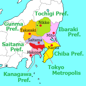
Choshi (銚子, Chiba Pref.) is a city located at the eastern tip of Kanto Region, and there are some spots such as fishing ports, Cape Inubo, long Byobugaura Cliffs.
In addition, small Choshi-dentetsu railway is unique.
Umi-hotaru (海ほたる, Chiba Pref.) is a rest area on the expressway connecting Tokyo area and the southern part of Chiba Prefecture.
The expressway crosses Tokyo Bay, and Umi-hotaru is just at the center of Tokyo Bay.
Kamogawa, Katsuura (鴨川, 勝浦, Chiba Pref.) are the towns in Boso Peninsula facing the Pacific Ocean.
Popular aquarium, unique island, Buddhist temples are around the coast.
Enoshima (江の島, Kanagawa Pref.) is a small island connected by a bridge and is near Kamakura city.
There is a Shinto shrine and scenic places are in the whole island.
Jogashima (城ヶ島, Kanagawa Pref.) is a small rocky island by the tip of Miura Peninsula forming the entrance of Tokyo Bay.
A bridge connect the island and the mainland, and the flat island is a natural park.
Choshi city Umi-hotaru Kamogawa, Katsuura Enoshima Jogashima
Izu Islands (伊豆諸島) and Ogasawara Islands (小笠原諸島) are the islands dotting on a line for 1,000 km to the south of Tokyo area.
They are from temperate to subtropical zones and most of them are volcanic islands.
There is a lot of nature and there are few gorgeous resort areas.
Izu Islands & Ogasawara Islands
Seas and Islands in Koshin-etsu Region
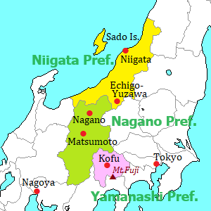
Sasagawa-nagare (笹川流れ, Niigata Pref.) is a coast facing the Sea of Japan.
Many uniquely shaped rocks are seen, and the clear water of the sea and the view of sunset are beautiful.
Sado (佐渡, Niigata Pref.) is a comparatively large island in the Sea of Japan.
There are some historical spots, old towns, the Japanese crested ibis registered as a special Japanese natural treasure, etc. in the island.
The gold mine in the 17th century was designated a World Heritage Site in 2024.
Seas and Islands in Hokuriku Region
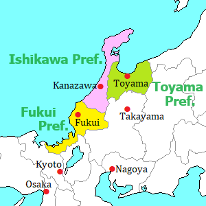
Amaharashi coast (雨晴海岸, Toyama Pref.) is located southwest of Toyama Bay.
A small and unique rock island is near the coast, and the view of Tateyama Mountain Range beyond the island is beautiful.
Noto Peninsula (能登半島, Ishikawa Pref.) is the northern part of Ishikawa Prefecture.
Small town and scenic spots are dotted along the coastline facing the Sea of Japan.
The whole area was seriously damaged in the earthquake on January 1, 2024, and it is slowly recovering.
Tojinbo (東尋坊, Fukui Pref.) is the very steep rocky coast facing the Sea of Japan.
The cliff with a lot of columnar joints is one of the largest three places in the world.
Mikata-goko (三方五湖, Fukui Pref.) is a group of five small lakes facing Wakasa Bay.
All lakes are connected with a narrow channel or a canal.
A scenic road is set up and a pleasure boat is operated.
Amaharashi coast Noto Peninsula in Ishikawa Prefecture Tojinbo Mikata-goko
Seas and Islands in Tokai Region
Atami (熱海, Shizuoka Pref.) is a major Onsen city near Hakone.
The city is on the slope facing the Pacific Ocean and there are many hotels with a fine view of the ocean.
Shimoda (下田, Shizuoka Pref.) is a city near the southern tip of Izu Peninsula.
It is a historical town facing a cove and there are some scenic spots of sea around the city.
West coast of Izu Peninsula (西伊豆, Shizuoka Pref.) faces Suruga Bay.
It faces west, so there are some scenic spots that the sunset is beautiful.
Miho no Matsubara (三保の松原, Shizuoka Pref.) is a beach with pine grove in Shizuoka city, and it is one of the best places to see Mt.Fuji.
When Mt.Fuji was registered as a World Heritage Site, the reasons included this beach.
Atami Shimoda West coast of Izu Miho no Matsubara
Meoto-iwa (夫婦岩, Mie Pref.) is a pair of rocks near the Futamigaura coast facing Ise Bay, and it is to the east of Ise Shrine.
It is said that a sacred stone is in the sea and Meoto-iwa is the Torii gate to worship the stone.
Toba (鳥羽, Mie Pref.) is the entrance city of Shima Peninsula and it is also located to the great shrine Ise-Jingu.
It is famous for the culture of pearls.
Shima Peninsula (志摩半島, Mie Pref.) forms the entrance of Ise Bay and the coastline is the ria coast and highly indented.
There are some spots to see the beautiful scenery of the sea.
Ama is a traditional woman fisher who dives into the sea near and catches expensive abalones and the other shells or seaweeds, and about 1,000 amas live in this peninsula.
Shichiri-mihama (七里御浜, Mie Pref.) is a straight coast in Kumano city and is a part of Kumano-Kodo which are the ancient pilgrimage routes designated a UNESCO World Heritage site.
There are a few spots of unique rocks.
Meoto-iwa Toba city Shima Peninsula Shichiri-mihama
Seas and Islands in Kansai Region
Amanohashidate (天橋立, Kyoto Pref.) is a scenic sandbar.
It is near the Sea of Japan far from central Kyoto city.
It has been a popular place since ancient times, and a few old temples are around the area.
Shirahama (白浜, Wakayama Pref.) is a resort town.
The name means "white beach", so there are some beautigul beaches.
In addition, it is an onsen resort.
Kushimoto (串本, Wakayama Pref.) is a town at the southern edge of Kii Peninsula, and it is also the southern edge of Hoshu island.
There are the unique rocks along the coast and the flat ground for observatory.
Akashi-Kaikyo Bridge (明石海峡大橋, Hyogo Pref.) is a suspension bridge for cars and crosses over Akashi Channel.
It connects Akashi city and Awajishima island, and it is on an important route from Kansai region to Shikoku Island.
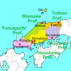
Seas and Islands in Chugoku Region
Shimanami Kaido (しまなみ海道, Hiroshima & Ehime Prefs.) is an expressway about 60 km long connecting Honshu Island and Shikoku Island.
The route passes six islands in Seto Inland Sea, and the whole route has scenic view.
Cars and bicycles can pass it.
Tomonoura (鞆の浦, Hiroshima Pref.) is a small port town facing Seto Inland Sea, and there is old town around the cove.
The ships sailing on the sea had waited for the change of the flow in this port in the old times.
Okunoshima (Rabbit Island) (大久野島, Hiroshima Pref.) is a small desert island, and it is located about 3 km off the coast.
About 400 wild rabbits are living in the island.
Tottori Sand Dunes (鳥取砂丘, Tottori Pref.) is the most popular sand dunes in Japan and faces the Sea of Japan.
The scenery is rare in Japan, and it has been designated a national monument.
Uradome Coast (浦富海岸, Tottori Pref.) is a ria coast about 15 km long, and is located to the northeast of Tottori Sand Dunes.
It is a national-designated site of scenic beauty and natural monument, and many rocky islands near the coast are seen.
Shimanami Kaido Tomonoura Rabbit Island Tottori Sand Dunes Uradome Coast
Inasa Beach (稲佐の浜, Shimane Pref.) is located 1.2 km west of sacred Izumo Shrine.
On the sand beach, there is a big rock in relation to Japanese myth.
Oki Islands (隠岐, Shimane Pref.) are located about 70 to 100 km north of Shimane Peninsula in the Sea of Japan.
In the middle ages, Oki was a place of exile and has the history that two Emperors were exiled.
The islands have the history and rich nature.
Oumijima island (青海島, Yamaguchi Pref.) is an island in the Sea of Japan, and is near Nagato city.
There are sheer cliffs and rocks along the northern coast, and the landscape is called "Alps in the sea".
Tsunoshima Bridge (角島大橋, Yamaguchi Pref.) is a bridge connecting Tsunoshima island and the mainland.
The color of the sea is beautiful like a resort and the beautiful landscape with the bridge is popular.
Shimonoseki (下関, Yamaguchi Pref.) is the city located at the western end of Honshu Island.
It faces Kanmon Straits like a wide canal and is the entrance to Kyushu island.
Inasa Beach Oki Islands Oumijima island Tsunoshima Bridge Shimonoseki
Seas and Islands in Shikoku Region
Shodoshima (小豆島, Kagawa Pref.) is the second largest island in Seto Inland Sea, and the cultivation of olive is well-known in the mild climate.
There are various sightseeing spots in the island.
Naoshima (直島, Kagawa Pref.) is a small island in Seto Inland Sea.
It is an island of modern art, and there are some museums, some outdoor art works are dotted in the island.
Honjima (本島, Kagawa Pref.) is one of Shiwaku Islands in Seto Inland Sea.
Pirates had lived in these islands since ancient times, and they were employed by the government as a navy in Seto Inland Sea in Edo Period.
So, the old town relating to them remains in this island.
Naruto Whirlpools (鳴門の渦潮, Tokushima Pref.) are the most popular and large-scale whirlpools in Japan.
The sea is a narrow strait and the whirlpools occur by moving of the massive amount of water between Seto Inland Sea and the Pacific Ocean by the rise and fall of the tides.
Cape Muroto (室戸岬, Kochi Pref.) is the cape at the south-east end of Shikoku Island.
High priest Kuukai in the 8th century attained enlightenment of Buddhism around this cape.
Cape Ashizuri (足摺岬, Kochi Pref.) is the cape at the south-west end of Shikoku Island.
The coast is very steep and rough waves of the Pacific Ocean wash the cape.
Naruto Whirlpools Cape Muroto Cape Ashizuri
Seas and Islands in Kyushu Region
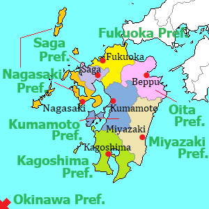
Mojiko Retro (門司港レトロ, Fukuoka Pref.) is the sightseeing spot facing Kanmon Straits between Honshu island and Kyushu island.
"Mojiko" is Moji Port, and the railway ferry had been operated from opposite Shimonoseki until 1942.
Mojiko had been the starting station of railway in Kyushu.
The buildings at that time are restored.
Umi no Nakamichi (海の中道, Fukuoka Pref.) is a sand bank near Fukuoka city.
There are wide flower gardens and large grassy fields, and amusement park, zoo, etc. are set up.
Shikanoshima is connected to the sand bank, and the golden seal given from China in the 1st century was excavated in the island.
Yobuko (呼子, Saga Pref.) is a district facing Genkai Sea in Karatsu city.
The squids unloaded at the fishing port are fresh and popular.
There are some sightseeing spots around the town.
Mojiko Retro Umi no Nakamichi Yobuko town
Gunkanjima (軍艦島, Nagasaki Pref.) is a small island near Nagasaki city.
It had been a coal mine until 1974, and it looks like a warship because many buildings and facilities are on the island.
A few guided tours are operated from Nagasaki Port.
Kujukushima (九十九島, Nagasaki Pref.) is a group of many small islands along the intended coast to the northwest of Sasebo city.
The scenery is attractive and the view of sunset is beautiful.
Fukue Island (福江島, Nagasaki Pref.) is one of Goto Islands to the west of mainland.
Samurai residences in the 17th century remain.
And, there are some Christian churches built after lifting of the ban of Christianity in 1873.
Amakusa (天草, Kumamoto Pref.) is the islands on the west side of Kumamoto Prefecture.
Because Christianity was banned in Japan in 1587, Japanese Christians had hidden in Amaskusa until the lifting of the ban of Christianity in 1873.
So there are also a few Christian churches in Amakusa.
Gunkanjima Kujukushima Fukue Island Amakusa
Aoshima (青島, Miyazaki Pref.) is a flat and small island.
The coast is covered with the bedrocks which have regular and straight stripes of geological layers.
Yakushima (屋久島, Kagoshima Pref.) is not so large, but very high and steep mountains tower in the island.
Rich forests cover the whole island, and the island is designated as a World Natural Heritage site.
Yoronjima (与論島, Kagoshima Pref.) is a small island surrounded by coral reef and is located just to the north of Okinawa Island.
There are beautiful beaches.
Okinawa (沖縄) is the prefecture located on the southwestern edge of Japan.
Subtropical islands are dotted on a line for 650 km.
Okinawa Island, Miyako Island and Ishigaki Island are the main islands.
There are many beach resorts in these islands.